This weekend was our Wedding Anniversary. Two years gone so quickly.
We booked a hotel we knew and liked and not far from home.
Anyway we went to Delph, and so i planned a circular walk just in case we fancied doing one.
It was a scorcher of a day and a walk had to be done.
Delph is a small village within the control of Oldham. It's a lovely place with a good atmosphere and lots of old mills and interesting buildings relating to the industry of wool spinning and printing.
Our circuit started at the excellent Old Bell Inn which is in the Guinness Book of records for having the most bottles of Gin, and proceeded through the carriage archway that used to be Lumb's Mill, then followed the River tame into the village centre passing numerous smaller mills and workshops on route.
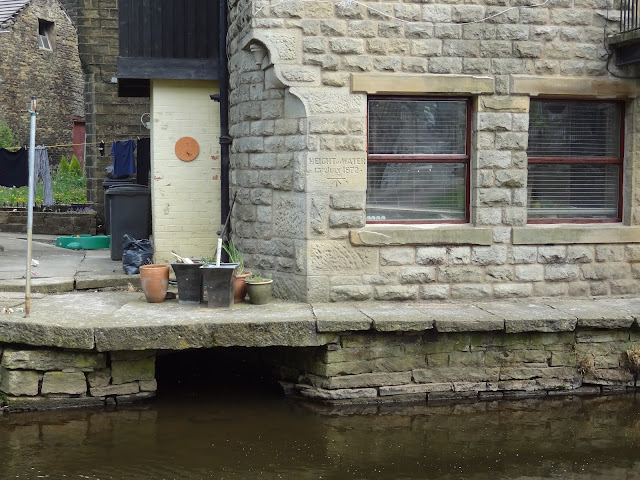
At the bridge which carries the main King Street, there is a cottage with a high water level stone which shows the water height from the floods of 1872.
Spot the height stone.
Following closely the River Tame, this valley is a delight to walk, especially on such a sunny day. Fields full of wild flowers dominated by lush green and yellow. Beyond Pingle Mill the huge old stonework of Linfitts Mill can still be seen hiding away in the undergrowth. These mills and this whole area would have been alive with activity during the 19th and early 20th centuries. Many signs of industry can still be seen in the leats, sluices and filled in mill ponds. A number of old water wheels and mill stones can also be found.Crossing the tame and climbing up to a car track, passed three old cars in need of restoration tucked away in a barn protected by a Doberman.
The Tame valley
Name that car? *
The unmistakeable Rolls.
We walked through a small hamlet just south of Slackcote which again was a joy to view. Renovation of the buildings done with a sympathetic eye. Across the busy and fast Denshaw Rd we crossed pretty meadows alongside a newly mowed cricket pitch and up to the now redundant church of St Thomas at Friarmere built in 1765 which has been in our view on the skyline for a while.The Royal Oak pub next to the church was unfortunately closed, we were too early for opening time.
Stones from Linfitts Mill
Cricket ground with the church on the skyline.
Lush Meadows of clover and buttercup dominating
St Thomas Friarmere at Heights.
Royal Oak Pub at Heights built 1767, two years after the Church.
We had a meander at this point, taking a right at the pub instead of going to the left, it was quickly rectified and the mistake only cost us 5 minutes.Just passed the pub we took a stile on the right that led us down to Grange and the minor road that gives a view to our next objective of Castleshaw reservoir and the Roman Fort to it's right.
Looking back towards Delph.
Looking back up the minor road from Grange. Our route is over the stile on the right.
Castleshaw Reservoir.
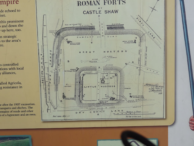
Following the minor road on the east side of the reservoir and turning onto Dirty Lane we entered the gate which leads to the Roman Fort (remains off). This is worth a visit alone if you like this kind of history. Built about AD.79 and abandoned about AD120. There are a couple of information boards and the footings of the walls, courtyards etc can be made out. Excavations were carried out in 1897 and in 1907/8.
The area of the fort.
Leaving this most interesting area we ascended the hillside to meet up with the A62 road near to Saddleworth Hotel at Hunters Hill. At this point the sky was increasingly becoming black. The thunder was rumbling around but no lightening. Heavy droplets of rain splattered the wide track and also our shirts. Our pace quickened but luckily the cloud was heading in the opposite direction so apart from getting slightly damp we didn't use waterproofs. The breeze increased too and it wasn't long before we could see the rain falling were we had been 10 minutes earlier.
Along Harrop Edge.
Here comes the rain again.
Looking down into the Diggle Valley from Lark Hill Lane.
W.H.Shaw Mill with the canal and railway just beyond.
Lark Hill Lane descends from harrop Edge to Diggle, it is very rough, steep in parts and is showing signs of just how much use this route gets. Care is needed. Once across the A670 it's a nice easy stroll to reach the Huddersfield Narrow Canal. We stopped at the lock in the image below for lunch, enjoying the sunshine now that the rain had moved on.
Huddersfield narrow Canal.
We followed the towpath on the south side until we reached the spot where the railway bridge crosses the A670 road. At this point we made use of the good cafe for a coffee and cake.
It was noisy, with kids screaming loudly and parents ignoring the racket. They are now obviously deaf due to being subjected to this noise every day. For us it was beyond our patience and we quickly left. The coffee and cake was however excellent.
A quick scan of the map had us crossing the canal and making our way onto the Delph Donkey Track, a now disused railway line which terminates at Delph. The track was in use from 1849 until 1963. Where the name originates is still unsure.
The track still has numerous information boards and being level walking soon brought us back to our start point in Delph. On the way we came across the most wonderful Bracket Fungi i have ever seen.
One of a number of information boards on the Delph Donkey railway line.
Stunning bracket fungi.
Who goes there!
Delph Donkey Station.
OUR ROUTE. Starting just below the name Delph on the top map.
It took us just over 5 hours. With 2 short stops but with numerous photograph pauses. It is a lovely route and well worth doing.
* Dawn thinks it may be a Bugatti.
I first thought it may be a Bean but i now think it might be a Morris Cowley.
Any other suggestions most welcome.
* Dawn thinks it may be a Bugatti.
I first thought it may be a Bean but i now think it might be a Morris Cowley.
Any other suggestions most welcome.


