Tuesday 26th February
After yesterday’s good weather it wasn’t hard for us to get out earlyish today. It was nippy because of the cloudless sky and the fact that we were in the shade at this time but the sun was there.
Walking through Crosby Garrett we felt as though we were the only folk around. So peaceful, it was just like stepping off the world, which we really needed to do right now.
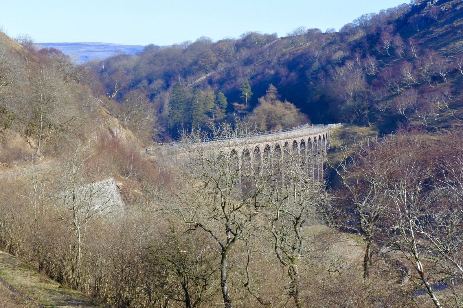
The railway viaduct with its 6 arches at the south west end of the village dominates the view and made me stand and contemplate for a few minutes what the locals must have been thinking during construction in 1871 of this 55 ft high and 110 yds long stone and brick masterpiece. Did the locals have any say, were they happy or resentful. How noisy was it with all the workmen, cranes, deliveries of goods etc. Where did the planners and overseers stay. Lots of questions with no answers.
The architect and builders John Sidney Crossley built similar structures, as part of his task of building the Settle to Carlisle railway for the Midland Railway Company between 1857 and 1875. He did a fine job.
Passing underneath the arches you have to admire the brickwork which is classed as skew.
Just beyond the viaduct there is a small round stone structure which reminded us of the pinfold which we saw recently on our Loweswater walk. Whether it is or not is uncertain.
At the old Limekilns, which now seem to have another use, ie burning the village rubbish, the trail splits, one way to Bents and the other to Nettle Hill. Our path headed to Bents on a good bridleway. It’s a nice route, grassy with good views.
Bents Camping Barn and Camping field.
We came upon a new Coast to Coast signpost just before Bents. I must admit I cannot remember this part of the C2C route at all. I remember the limestone pavement and Sunbiggin tarn and the horrendous rain, but not Bents. Oh well.
My original plan, as shown on the map was to cross the disused railway and use the footpaths south of the old railway track to take us to Smardale Bridge. As it happened, I decided to stick with the railway path. I wanted to take a look at Severals which is a prehistoric settlement. It’s never been dug but there wasn’t much to see. It’s far better looking at it on Google Earth. Wainwright actually says as much in his C2C book.
Our Route plan.
Disused Railway Path
Whats left of the signal box.
The signal box was closed in 1931, this happened because the line was reduced to single track to Ravenstonedale. It was excavated in 2005 by the volunteers of the Stainmore Railway Company.
Smardale Bridge and Scandal Beck.
Reaching the high point above Smardale Bridge I was glad I chose this route, the view of the bridge and beyond down Scandal Beck towards Ravenstonedale is very nice. A little further on you pass a couple of empty houses and then two more Limekilns which are huge and in decent condition. I read that they are to be preserved which is great. There’s an easy way up onto the top of the kilns by going by the quarry on the right hand side. At the top there is the derelict engine house which used to pull the limestone along an inclined plane. The tops of the kilns were collapsed and there was lots of vegetation growing.
The benefit of getting to the top of the kilns is the fantastic aspect it gives you of the Smardale Gill viaduct. Recently restored and looking good.
Being a sunny day the shadows were long and made for some nice photos and a place for lunch.
Smardale Gill Viaduct
We stayed on the railway path where Sheila found a Flugelhorn just lying around, until the junction with Smardale Hall and where the old Smardale Station used to be. The station house is now a splendid home. Next to the station house we noticed there was lots of Private signs and No Parking notices. Obviously this very small car park which I guess was probably a yard or such like belonging to the railway company years ago is a busy place at weekends and probably a favourite with dog walkers.
Smardale station didn't serve a village, there isn't and never was a Smardale Village. It just served the numerous farms and business's that surround it.
I was hoping to have a look at the Hall close up as it was built in the 15th and 16th centuries on top of a 14th century Tower House. But it wasn’t to be as the sign says Private and also the sun was directly above the house meaning photographs were not great. Only later did I notice that a small lane passes behind the hall and we could have made the short journey to see.
As it was we headed off down the lane until we came to Scandal Beck again with a ford and pedestrian footbridge. Sheila headed for the ford and nearly fell in because it was so slippery. I was glad for the scout and headed for the bridge. On the other side the sun was very warm and so we took advantage of a stile for a seat.
We stayed for about 15 minutes just taking in the peace and quiet and listening to the mellifluous sounds of numerous birds in the bushes along the beck.
The footbridge and ford at Scandal Beck
It was indeed a shame to move but it had to be done. The field paths over the stile followed the river bank as far as the footbridge which if crossed leads to Smardale Mill. We didn't go to the "Mill", because today it is just a farm. We left the beck here and followed an old green pathway which leads directly to Crosby Garrett. Obviously many moons ago this would have been the locals way to work.
This walk was a fascinating one for us and we will extend it next time we are here. Hopefully soon.