The Vault Regulars

Wednesday, December 28, 2022

A photo blog post of our short walk along the beach at Walney Island.

Christmas Eve, 2022.🎅🎄


I think these were Stint.
WW2 relic of a large gun emplacement. (Many of these still to be seen).
View North from just before Shope Tree Scar


Long range shot of Stonechat with iPhone 11.

A lovely route to walk or cycle.


Tuesday, October 25, 2022

Jubilee Tower, Darwen Hill and Darwen Moor,

 Walked on Tuesday 25th October 2022.

Well here we are again heading North from home, fighting the traffic on the M60 circular to get onto the A666 which will take us through Bolton and to our start point for this walk at Ryal Fold. The 4 lanes on the smart motorway have not made the slightest bit of difference to traffic congestion whatsoever. Except the motorway is a far more dangerous place.

Arriving at the free car park I already feel shattered from the amount of traffic encountered. I hate driving.

Today I have planned a 10/12Km walk which will take in reservoirs, a grand viewpoint, open moorland and a river walk through forestry. Weather wise it isn't a grand day like we had last Tuesday, but hey, it isn't raining and I can see the tops.

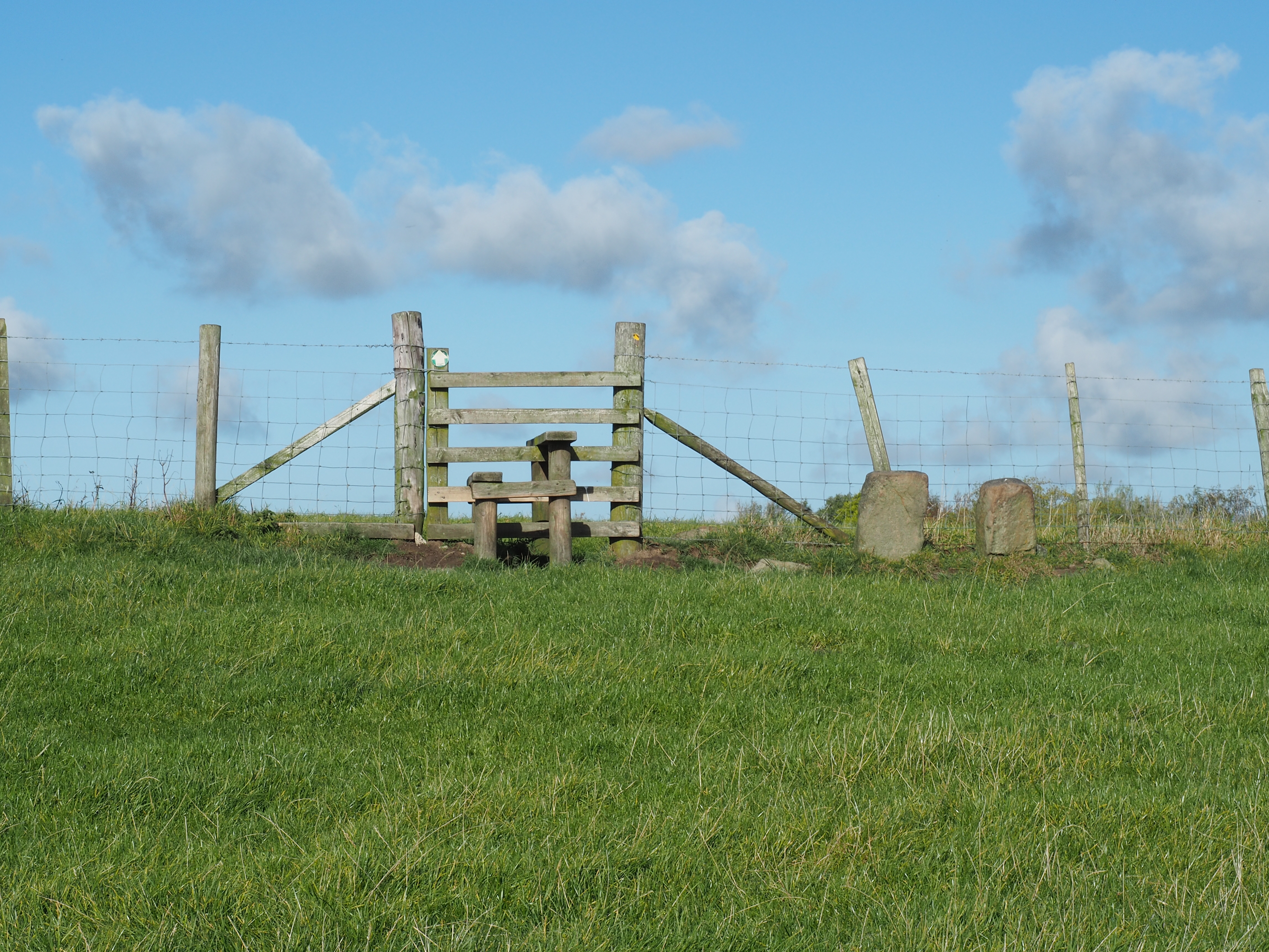
More or less straight away I took a wrong turn but realised within a hundred metres. I turned right on the path which goes towards Stepback Brook instead of going left through Ryal Farm which is a listed building. 

Looking at the building I'm not 100% certain that listing ensures the best treatment. In this case I would have my doubts. The building dates from the mid 1600 and belonged to the Walmsley family.

Ryal Farm, built Circa 1650
We were togged out for a nippy day and it wasn't long before the layers came off. The sun was really strong but it didn't make for good images. Through the fields full of ewe's with the admiring tups in an adjacent field we emerged onto a green lane which was aptly named Donkey Brew. This is a neatly cobbled old road leading down to Earnsdale Reservoir.

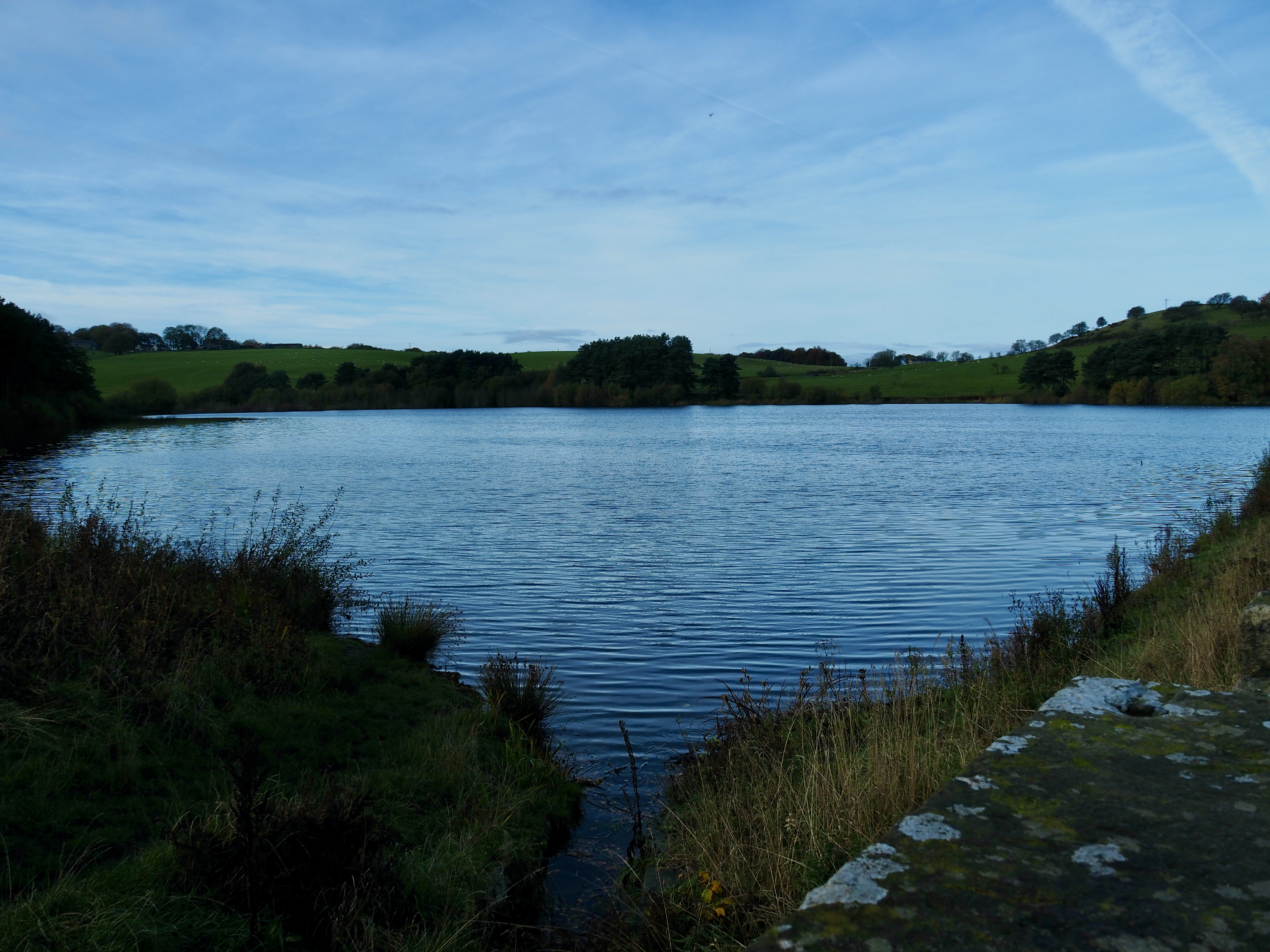
The reservoir was built in 1863 and is fed by Stepback Brook.

Easdale reservoir, the path goes across the dam head.


Looking at the map, the track looks like a Land Rover track but we were surprised to find it mettled for quite a way. Approaching the Water House, a lovely York stone house we were greeted by a couple of alpaca. Beyond the house we passed through a gate on the right. Above us but out of sight unfortunately was another reservoir, Sunnyhurst Hey. It wouldn't be until we got to Jubilee Tower that we would get to see it. However, the views north towards Longridge Fell was great.

A few dog walkers were enjoying the weather as we plodded upwards towards the tower. Our fitness or I should say lack of fitness coming to the fore. Darwin down to our left. 

On the way up Darwen Hill to Jubilee Tower.
Still a bit to go yet.
Darwen
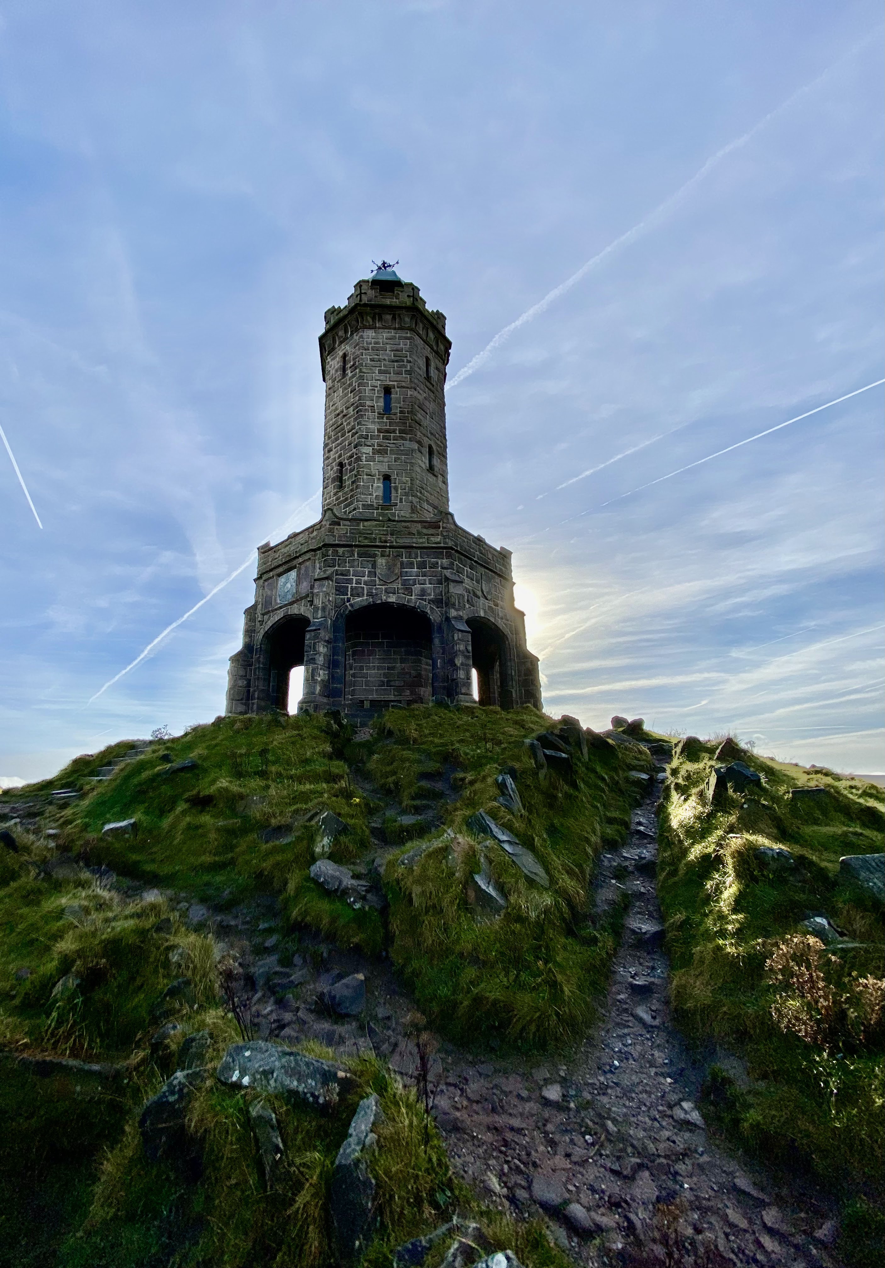
A very pleasant "up" soon brought us to the tower at 372 metres and the OS Trig point osbm S3476. It was surprising that we had the tower to ourselves. I didn't expect that on such a nice day. We did the climb to the top and wow what a view. The tower was built to celebrate Queen Victoria's Jubilee year. It is worth a visit.


After around 20 minutes enjoying the views from the tower I had to check the map to find our onward route. This was simply because there are so many paths heading off in all directions from the tower. As it happens our route followed the Witton Weavers Trail. I've done small sections of this trail but I wouldn't mind doing it all in one go. 

The moorland was a delight and the sound of grouse, which sounds like they were laughing at us could be heard as we disturbed them. The wind was a bit chilly and we needed to keep moving until we got into the lee where we stopped for a few minutes at one of the many benches situated on the tops.

We must have been lucky as around the hills to the east and for long periods on Winter Hill a band of thick white cloud covered the tops. We were now walking west on an extremely wide grassy path which must have been mowed by machine. We were now about halfway. The tower still constantly in our rear view.
Heading west into clear sky. Not a soul around.

Winter Hill starting to clear.
Walking down the motorway track I kept thinking "Thats a good spot to camp, oh and there's running water". Noted in memory bank. 
At the access point into open country the tower looked so close. 

All too soon we head downhill towards the road where looking at the map is a car park and picnic area. We will stop here for lunch and then into the forestry which hold deer and the ruin of Hollinshed Hall.
The car park was there but the barrier was locked up. As for the picnic area, well that was none existent. So we used a decent enough low wall as a table.  The sign in the car park said it was overspill only. Also if you did manage to park and you were not out by 5.30pm, YES, 5.30pm, you would be locked in and that would be that until the barrier was unlocked the next day. Wonderful I thought. Must put a hacksaw in the boot I thought. There was no sign that you couldn't cut the barrier so I presume that it would be ok.

Lunch. 
The 2 mini buses were for a children's outing, I presume the driver had his own keys to the barrier. 

The walk through the plantation was an absolute delight. Mixed woodland and obviously the grounds which belonged to the now ruined Hollinshead Hall. The hall was built on the grounds of a former farm in 1776 by John Hollinshead. It eventually feel into disrepair and when the land was purchased by Liverpool Corporation Waterworks in the 1900's it was demolished. Apart from the well house which still stands.


The well house and below a blurry image of the interior. 2 images thanks to Lancashirepast.

Leaving the old hall behind and following a good path through the plantation we spoke to a chap keen to show us the photographs he had taken of a stag and doe. They were taken here and no wonder he was proud of them. 
Also, all around was a plethora of fungi. I so wish I had brought a flash for the camera because there was some beuts.
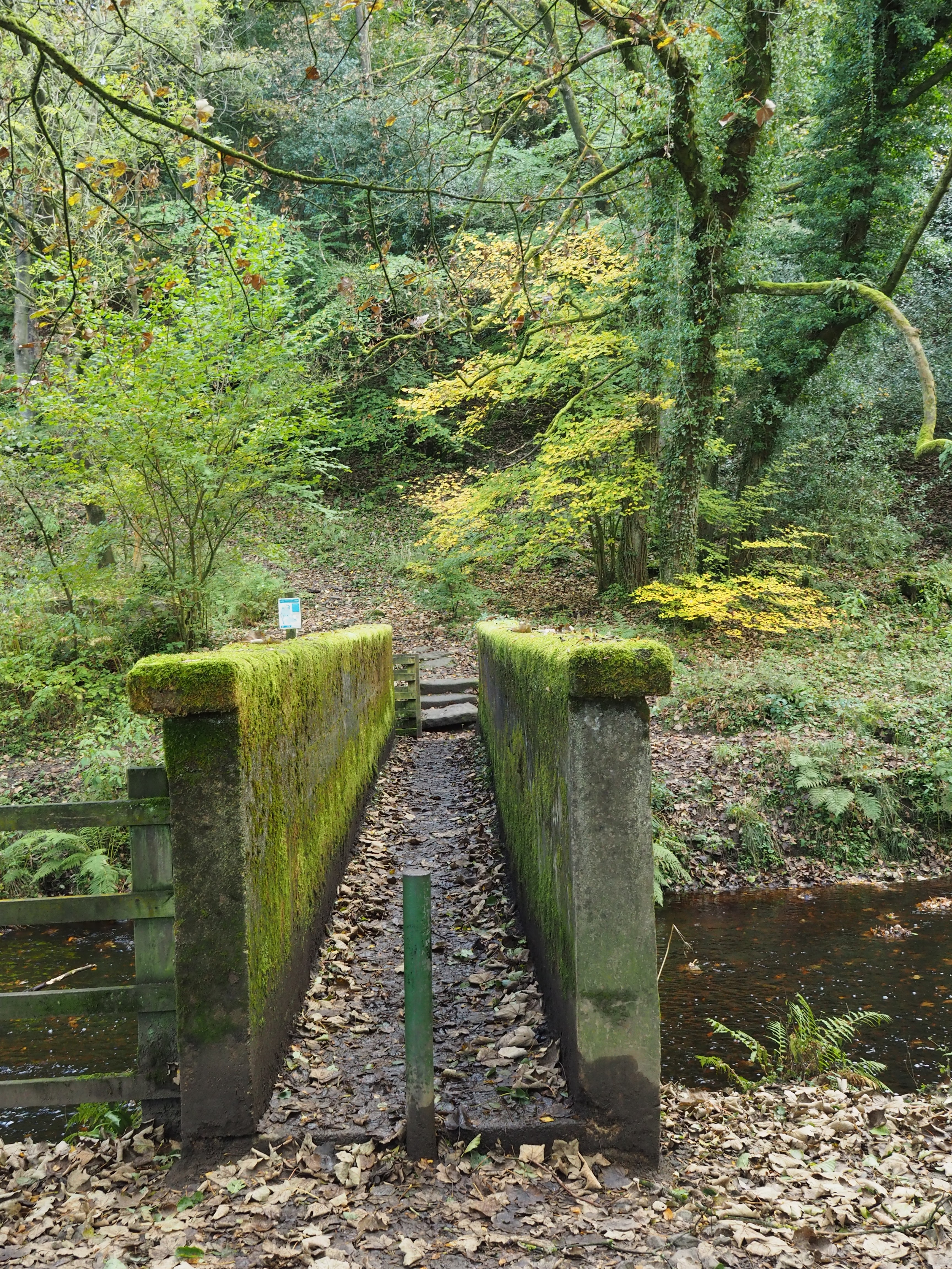
Numerous times the sound of the river could be heard but not seen and it was quite a while before it came into view. At the bridge over to Roddlesworth I took the photo below.


This walk has been one of my favourites for some time. Scenery so mixed and lots of fungi at this time of year. It was a good outing for both me with my tendonitis and Sheila with her sore hip. What a pair of crocks. But there was quite a lot of up's and downs so it is progress. 

Here's the route, about 11km.


And it wouldn't be a walk without a tractor. An MF265.


Tuesday, October 18, 2022

To Wheelton, to see the sea?

Walked on Tuesday 18th October 2022.

 This walk was from a book that I have had since the late 1990's and was written by Mike Cresswell, it is the first time we had walked the route as laid down by the author. I wondered just how much would have changed in all that time, considering all the development of recent times. As it turned out there was only one small detour needed where a new house had been built in Wheelton.

We parked the car at SD6051 2202 which is the junction of the Wheelton By-Pass and the side road of Whinns Lane. It was a lovely spring like day with blue skies and plenty of cloud inversions.

We set off down Whinns Lane and passed a Vegan Restaurant which was in a grand spot too admire the views. A little further we got the first glimpses of the Leeds-Liverpool canal through the trees.

Just before a bend and a row of cottages a high wall with a footpath sign on the left is seen. Take this tight narrow path for a hundred metres or so and through the gate into a field. The first of many.


Once into the field keep the tree line on the right and follow this, then a fenced lane and through the next gate. Down below and to the right is a new build/barn conversion. Head close to the left of it and then skirt the front of the building over a style, turning then left onto Stable Lane and left again onto Victoria Street.
Cross the Wheelton By-pass and head up the lane opposite with the Dresser Arms Pub on the left. 


We was hoping to see the sea as we gained hight along Briers Lane at Southport or Blackpool but today the plain was covered with a cloud inversion and we couldn't see any sign of the sea. Further along the lane I spotted our first and only OS benchmark of the day

The benchmark can be found on the wall at No.4 Briers Lane. It's a cut benchmark. Highlighted below.
Cut benchmark at SD 6065 2116. Verified in 1957 and also today.

Carry on up the lane until you come to a sharp right hand bend. At this point leave the road and take the Land Rover Track in front of you. The route goes between 2 lovely houses and over a stile into a field with great views across to Winter Hill, Chorley, Wheelton Moors and where we are heading for, Wheelton Plantation.
Follow the fence line on the right and about half way down the hill the route goes right along a fenced path heading towards Logwood Mill Farm with the equine centre. As you approach the buildings take the path to the left and follow it through the equine centre and passed the refurbished cottage and mill. 


Walk down the drive and after a few minutes when you come to a T junction at SD 61587 20513 take a right and follow this round to the left over a bridge and through a farm and fencing supplier to another T junction where we take the right track leading to the bridge over the dismantled railway.
(Note the track on the os map from SD 61587 20513 which goes in an ESE direction to SD 61717 20429 is now so overgrown as to be non existent.)
The dismantled railway was run by the Lancashire and Yorkshire and London Western Railway companies. It ran between Chorley and Cherry Tree, Blackburn. It opened in 1869 and it was 2 yrs late and way over budget. (Nothing has changed then.) It closed to passengers in 1960 and for goods in 1966. 

Remains of the railway route.
Over the bridge bear left along a lovely lane full of Oaks and Holly and we spotted Nuthatches here. Follow it around until you come to a gate with a bridge across the River Goit. Don't cross the bridge but take the waterside path to the left and follow it until you come to a narrow concrete bridge crossing the Goit.

The path alongside the Goit is a pleasurable tree lined way with lots of bird life and at this time of year lots of fungi to see.


All too soon we come to the concrete bridge which we cross and head up hill bearing slightly left. Keep going uphill until you come to a double arched stone ruin of Blackhurst stables with steel fencing and small doorways. Go behind this stables and pickup a good wide pathway. Turn left and follow all the way to a metal gate with a huge slab of stone on its right. Go through the gate and pick up the path on the left heading down hill.
Cross this concrete bridge.


Heading up to Blackhurst Stables.

These arches are what is left of the stables which were part of the the now ruined Blackhurst Mansion. Within these woods there are lots of interesting ruins to explore. Another time.

At the bottom of the track we again joined the banks of the Goit. Cross the bridge. Here we met Winston and three of his mates and their owner. Winston is an old boy, very friendly and he still likes the odd cigar on a walk.

Just beyond the bridge and across a small road we walked under an old railway bridge. The onward track takes a left after a hundred metres and comes to a T junction with Brinscall Hall standing opposite. The Hall is not easy to see from this viewpoint but there is a wonderful old clock tower and a lovely row of new build properties. At one of the properties we met Albert, the white cat. This is his daytime name and not his triple hyphened show name. He was a real poser who obviously liked to sunbathe.


Brinscall Hall, photo thanks to Phil Platt.
The Hall, now a retreats centre for Philosophical study, meditation and the Arts was built in 1896 by William Christopher Wood.

Walking passed the front of the properties go through a wrought iron gate and bear right into a field. Look up to the ridge top and you spot a stile. Head for this stile. As it happens this turned out to be our lunch spot. The views are wonderful.
Lunch spot.

Darwin Tower and Darwin Moor.
We climbed the stile and crossed the field to another stile leading passed 2 beautiful hoses and then the minor road.

Turning left we passed the position where the footpath is shown on the map. This path has now been moved further down the road (about 50 metres) and a horse stable and paddocks is now there. Find the stile opposite a fantastic house with a floor to ceiling window showing the fantastic staircase. Wow.
And then we saw Blackpool Tower. I wondered why this area was called Harbour? It's certainly a long way from the sea.


From here the route crosses many fields and a golf course. It is almost impossible to write the route but I will say that care is needed to pick out stiles as some are hidden in-between trees. However, we managed it ok with only I hic up at the 2nd stile as we proceed through the golf course. 

We exited from the field paths at Triggs Barn onto Fishwick Lane in Wheelton. Turning left on the main road (Chorley Rd), passed the old School House where we found the footpath on the right which leads to the Leeds Liverpool Canal. There is a path change here which must have happened with the building of a new house, a big house.
The non existent path starts at SD 60472 22303 and should lead across to the canal according to the OS map. The route to the canal now goes over the stile at SD60539 22323 and uses an old farm track leading to a metal bridge over the canal. 

In an adjacent field were a flock of Pygmy Goats and one in particular stood out. I think Sheila wanted to bring it home.


We turned left along the towpath to Bridge 83 passing quite a few narrow boats moored up. One of them was quite unusual for a canal in UK and looked like it should be in Holland.


The path from the bridge led in a few minutes back to Whinns Lane and the car. 

The route is here. 10.5km which took us 3.5hrs which included 15minutes for lunch and numerous stops for photos.

Oh yes, We saw lots of tractors on this walk. Here's just a couple.
This is a MF40e 2 wheel drive machine, the digger on the back was an accessory available to be fitted. It wasn't built on the assembly line with this digger on. We did fit them and also air compressors as an extra.

This is an Iseka tractor. It's a Japanese company but it has done lots of badging deals with companies like Massey Ferguson, Porsche, White, Challenger and others. They are mainly used as grass cutting machines. You don't see too many of these in UK.


Find it Here

About Me

My other blog. beneathwhosefeet.wordpress.com