The Vault Regulars

Showing posts with label walk Lakes. Show all posts

Wednesday, July 23, 2025

GUMMERS HOW - CIRCULAR

 Sunday 20th July 2025

The car park at SD38958763 on Fell Foot Brow was quite busy when we arrived. Lots of folk milling around chatting. We managed to park up but the lay bye’s on the road still had plenty of room. It’s a busy spot for some reason. I guess it’s the proximity to the road and the great view of Windermere from the top. 

Walking through the car park a short path is used through the woodland, emerging at a gate leading across the road and through another gate to the Gummer How path. 

There a notice board that informs you of what is happening in the surrounding area. 


On the way up we encounter a few people on their way down, quite a few young children are stood wondering what to do about these brown and white giant beasts which are blocking the path. 

The cows have calf’s and they are lay down all over the place. They are not a bit bothered about the humans and neither are their mums and Dad. Lots of photos are being taken and we join in. The breed has been selected by Defra along with the landowner and Natural England. They are Luing, from Argyle.


The path up to the summit is easy although the direct route involves a little bit of hands on. It’s far from difficult and there are many easy options to both sides. 

The view from the top today is stunning. The length of Windermere is visible as are the Coniston Fells and the coast down to Morecombe Bay. We are so lucky with the visibility today. 

I hadn’t realised just how large the Town Head House Estate was. Its size clearly appreciated from the cairn atop Gummers How. 


We head off in the direction of the small reservoir to the east in a plantation called Birch Fell. The path winds its way down, eventually meeting up with a fence surrounding the reservoir. Care is needed during the descent in bad weather as there are a couple of steep drops. 

A stile over the fence allows walkers to get to the reservoir area. We didn’t go over even though it looked enticing. 
We followed the fence line south until in 10 minutes it joined up with the path going up Gummer How. 
Although this top is easy it’s still worth doing if just for the views alone as it is the highest point in the area. 

Cannot say I have come across this badge before so if anyone has a name for it please leave a comment.

Birch Plantation Reservoir (Un-named)

Back across the main road and into the woodland we followed the footpath leading to Sow How Lane which we followed through the farm of the same name. Quite a few bikers use this route too although there are lots of gates to open and close.

Through 2 fields of sheep of varying breeds and through 2 gates we left the main  track for a footpath heading into the forestry and towards Simpson Ground reservoir. It was soaking wet in the forestry, dark and with lots of wind blown trees.

It started raining and went very dark. It was that fine rain which wets you through. It was time to don waterproofs but because the humidity was so high we decided to delay putting them on. The trees sheltered us to some degree which was very welcome.

One of the many MF tractors at Sow How Farm. Probably having a bit of a service. MF 6180

Looking back at Sow How farm.
Entering Astley's Plantation.

Out of the woodland we came to the wall of the reservoir dam. It seemed quite out of place. I managed to scramble up the wall using the fence atop to gain a photo position. I should have known better after my episode in Greece.

Simpson ground reservoir. Getting darker.

Back on track we were almost run over by a utilities vehicle which came around a blind bend going to the reservoir. It was really quite dark now and as we left the shelter of the forestry we had to put on waterproofs. The hills disappeared as the rain swept in. It wasn’t long before our thin lightweight, useless, waterproofs were swamped. Why we ever buy 2 layer waterproofs is beyond me but I always consider that good makes like RAB and MARMOT know what they are designing and they will work. But they don’t. They never do and we waste lots of money.

The rain was now teeming, the ground more and more sodden making the footpaths into rivers. I checked the map and we were heading into more woodland and guessed that it would be better if we stayed on a reasonable track in the open rather than get even wetter in the woods where the humidity was still high. It meant that we would be shortening our planned route but it was no fun.

Another small lake came into view near Simpson’s ground allotment but there was a “private” sign on the gate. Approaching Poor House Allotment we were met by 2 drenched mountain bikers on what looked like very expensive bikes. I didn’t get a photo as we were negotiating a gate for them to pass through without alighting.


Private pond on Simpsons Allotment

Rain was still sweeping across the fells, sometimes you could see a hill the next nothing. Sheila had completely lost her bearings at this point and thought we should have been going in a different direction. I checked the map and showed her where we were and where we were heading. Because of the weather it did seem as though we were walking further than we actually were. I’m glad I decided to change our planned route for a shorter one.

When we reached the minor road at Poor House we turned left (north east) heading for Foxfield Farms. The rain eased a little and it was a bit brighter. The narrow road eventually turned into a track and walking was pleasant and easy although with numerous undulations. I noticed 2 logging vehicles tucked away but I managed a photo. I’m not sure of the make or model.


Marshall 802 2WD tractor at Foxfield Farm. Circa 1982/4

The track eventually brought us back into the grounds of Sow How Farm where we took a side track to another lake which we spotted through the trees. Appropriately named Sow How Tarn. We had seen people there earlier and thought it would be a good spot to have a coffee etc. We were quite peckish now.
Unfortunately once again the “private” sign was in abundance, stopping us from going to the waters edge. We found a large tree stump for baggin’ time.
The tarn is not natural but a man made Fishery with a very nice boathouse.

Late lunch spot at Sow How Tarn.
Sow How Tarn.
No idea.

At the start of the next shower we packed up and headed back towards the farm. Good to see the farmer was a Massey Ferguson fan as there must have been 6 or 7 tractors parked up. I managed a photo of a couple of them.

Once again, instead of entering the woodland, we stayed on the farm road where we reached the minor fell road leading back to the car park.

Somebody must have been looking after us because we had only just taken our boots off and sat in the car finishing what was left of our coffee when the heavens opened. It was a huge downpour and I felt sorry for all the people out, walking Gummers How etc with only lightweight gear, if any, they would have been totally soaked to the skin.

Luckily back at the car.

Route..... 11km 3.5hrs.


Monday, February 6, 2017

Walna Scar, White Pike and White Maiden. (From Dunnerdale)

The Duddon valley was quiet. Any noise being masked by the low mist. Tarn Beck was in spate and sound of the rushing water was quite musical. There was no one around except Sheila and I, no cars, tractors or kids breaking the silence, just the tapping of a Greater Spotted Woodpecker high up in an adjacent tree.
Occasionally part of the surrounding ridge line would appear and then it was gone but there was enough time for us to see that the tops were white with snow. From the look of it the snow line started at around 500 metres.
In the valley the temperature was high for this time of year at around 8 degrees.C. No wonder the clagg was down.

Walking through the fields between Turner Hall Campsite and High Moss showed signs of previous heavy rains. Water logged ground in abundance. Beyond High Moss a tall ladder stile crosses the boundary wall and from there we could see that no one was camping.
At the start of the Walna Scar the high temperature had us both taking layers off. No sooner had we set off again when hail started to fall. Stop again to put waterproofs back on. For the next twenty minutes we had all four seasons.
Mid way up the Walna, the clagg thankfully lifted and we saw eight tiny figures almost at the top. Amazingly the snow line was receding fast, it was certainly a bit higher now than it had been when we first glimpsed the tops earlier on.
The Walna is a steady climb and today was proving how unfit we both are. Numerous pauses made between  the slow progress. My knee ached as it has been for some time now and I was hoping that the top wouldn't be too slippery and cause me problems.

                              The start of the Wana Scar road with Harter Fell in background.

As it happened we caught up with the eight folk we saw earlier. Three carried on up to Buck Pike whilst the others stood and drank warm drinks.
The col where the Walna starts to drop down to Coniston was bitterly cold and a biting wind was painful on the face. My anemometer showed 20mph wind speed but a temperature of 4C. It seemed far colder than that, we layered up again, putting everything on including a new pair of goggles which stopped our eyes watering perfusely. They worked fantastically well and will be staying in the rucksack. We had a couple of new bits of kit which I will say more about in a separate post.
Looking down the Duddon Valley from The Walna Scar Rd,

Top of the Walna looking to Coniston Water.

It was too cold to linger and the mist was coming in again taking away our views but it was fast moving mist with the strong wind. The views we had down to Coniston water and out to sea were dark and foreboding, occasionally the sun would burst through the black cloud in strong sunbeams.
My camera doesn't do justice to the light show.
 Top of the Walna Rd, with the path up to Dow Crag behind left.

 Clagg closing in again.

On Walna Scar 621 metres, en route to White Pike.

We headed for White Pike using the path which crosses Walna Scar along the ridge. Behind us Dow Crag and Coniston Old Man recieved fleeting glimpses. Across to our left Harter fell and beyond that the Scafells had their heads covered.
The hail returned and this time along with the powerful wind. The goggles were working a treat and didn't fog up, but most importantly gave us the advantage of having a clear unrestricted view.
As we approached the summit of White Pike 598 metres, we came across footprints in the snow coming from the opposite direction to ours. We hadn't seen anyone so this person must have been out early?
The top of White Pike has a couple of stone cairns and a windbreak of sorts. No use to us today, it was too cold to linger here. As we were taking the usual summit photos three walkers approached and also didn't linger.
 Sheila sporting useful goggles. Almost at White Pike Top.

View of Dow Crag from White Pike.

We set off for White Maiden 610 metres, just a short distance away. Here in between the wall and the crags we found a sheltered spot to have a rewarding coffee. The three walkers followed behind us but didn't stop, heading off down towards Torver.
Zoom shot of Dow Crag (left) and sun on Old Man of Coniston.

Instead of returning we same way as we came I decided to just walk off the ridge (safely I may add) and head straight down to the wall gate at SD250963. It was a slippery route and I had to be careful not to stress my knee. The Herdwick sheep stared at us and probably thinking that we were mad. I would have agreed with them.
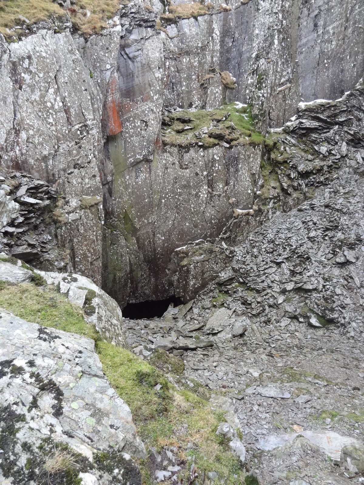
We got to the gate safe and sound and headed for Walna Quarry. The cave in the quarry would make a good place to have our sandwiches i thought. There are actually 2 caves in the quarries, the first one we found to be inaccessible due to a rock fall in the entrance alleyway. This is the biggest cave, so it was a bit disappointing. The 2nd cave is smaller and was accessible but the slate slabs were so slippery we didn't bother trying to get down to it. We were sheltered in the quarry so just decided to find a decent place to sit and have lunch.
Looking round there is still evidence of the quarrymens work. Drill holes ready for sticks of dynamite visible.
Heading down off the tops. Harter Fell now clear.

The 2nd cave which we found too slippery to access.

No sooner had we finished lunch when it went very dark again and the hail started. We set off out through the many quarry buildings, now ruins. There was no shelter.
 Dark clouds approaching fast.

 Sunny one minute.

Dark and hail stoning the next.

The hail was short lived, lasting only 10 minutes. Our route down now joined the Walna Rd again. Coming up to us were two runners and we mentioned to them that it was bitterly cold up on the top. They said they knew already as they had ran over White Pike earlier. We guessed that it must have been their footprints we saw.
Down at the road the temperature was warm and the wind non existent. The layers came off again.
The Woodpecker was still hammering away and the valley had come to life with numerous canoeists.
Greater Spotted Woodpecker, high up in the trees.

Our route today is below. It was 11km. We didn't do this walk in the time showed below on the map. It took us 4 hrs with stops.

Sunday, September 6, 2015

A weekend in Cumbria.

The fantastic clear weather was a joy to behold after weeks of grey and rain.
Sheila and i spent the weekend in the company of friends in the Duddon Valley.
It was one of the most chilled weekends we have had for sometime and saw us just wandering around without a fixed plan.
The above photograph was taken to highlight the fact that the forestry are re-planting thousands of trees either side of Birker Fell road. So in a few years time the amazing views and open land will be severely restricted.

I didn’t take too many photographs but what i did take i have made into a slideshow. There are only 32 images so watching it will not take up too much of readers time.
The beach scenes are at Seascale and the mountain scenes were taken on and around Irton Pike.
The friendly Sparrowhawk was taken through the window at our friends house.

The slideshow is Here.
Trial

Wednesday, August 12, 2015

Sunday, and it tested more than the tent.

Overnight the rain poured, with the tent being really taught the rain landing on it sounded great. We lay there and eventually dropped off to sleep. I was woken in the early hours to the wind being quite fierce and the tent door flapping noisily. I thought the door guy line may have come loose but it was still secure. So what was causing the flapping? It was too dark and too wet to get out and check. I pushed a *walking pole against the fabric and dropped back off to sleep.
It was a warm night and i kept peeling back the sleeping bag in an attempt to cool down. We had brought our light Rab bags but tonight they were just a bit too warm.

Daylight, 7.00am and its still windy and lashing down. Sheila looked out and we were completely clagged in. Couldn’t see a thing. I was then quite pleased that we had camped lower down.

We didn’t have to make a move and so we tried to get back to sleep for while. 9.30am came around and there was no change to the weather. We had spoken to a farmer on Friday and were told that Sunday would be a reasonable day with a few showers and improving. How wrong.

Boredom was setting in by now and so i decided we might as well make breakfast, coffee and porridge from the bag. No washing up you see.
10.00am It was still raining hard but the fog had lifted very slightly.We had to put plan B into action and so i discussed that we should stay low level, follow the River Duddon back down to Fickle Steps, cross over the stepping stones, which may be fun with the river running high and fast and then head to Turner Hall campsite.

Plan agreed we packed up everything inside the tent. No water ingress in the tent btw. We sat there fully clothed for the wet ahead, and said “right, lets go for it". Just as i got out of the tent and right on cue a big gust of wind hit the tent and i got an idea of what was causing the door flapping during the night. More to come on the tent when i do a field review, next post.

Quickly and very efficiently considering the conditions we dropped the tent and had it packed in about 4 minutes. Very impressed we were.
Heading for Black Hall and the approach path to the riverside the ground was very saturated which was not a surprise really.
I wondered, but said nothing, if at some point we would get cut off, maybe the river had flooded and we would have to make a detour back.
Castle How
The path between Black Hall and Castle How was passable with only the occasional minor detours to avoid the bigger deep pools. The side streams were flowing fast but strategically placed rocks made life a bit easier.
The path from Castle How to Froth Pot and the car park would have been better as a canoeing course.
It was deep and difficult and the grass and ferns high, this resulted in us being absolutely drenched.
Picking our way onto the higher clumps of grass took time and concentration. Eventually we got to the bridge and just laughed at how bad it was and that Plan B was right or maybe a Plan C should have been put into action. IE, use the road.


We new that our original intended high route would encounter very high ferns and that we would be soaked. It would be most unpleasant crossing Tarn Beck, that’s if we got there.

We had 5 minutes rest at the bridge and then carried on. The ferns were so high i managed to miss the path which leads to Birks Bridge but we ended up on the decent track to Birks farm. We didn’t have to retrace our steps but i wanted to stay on the river path. The river at Birks is always a delight and no more so than when in Spate. The rain was not easing at all but the hill fog had started to lift a few hundred metres. At least we were now getting a bit of a view.
Birks Bridge. (Aptly named)
The river at Birks Bridge.
Continuing on the river path i again missed the turn off which leads through the Great Wood and climbs a high crag. Instead i blinkeredly stayed with the river which today was impassable. At a shear drop into a deep pool we turned back and i found the higher path. The ferns were above our heads and it made staying on the “path” a bit hit and miss. It was satcherated and along with the heavy rain soon overwhelmed both our waterproofs. Sheila was feeling very claustrophobic in the jungle of ferns and we were being attacked by thousands of Black Flies. They didn’t bite but they were all over our face and hands.
I must admit to being very pleased when we hit the narrow, steep but clear path which goes from Troutal to Birks farm.

Here at the bridge we decided Plan C was after all required. It was an easy decision. Cross the bridge which comes out at Troutal and hit the valley road. It was fantastic to be out of the wet foliage. No sooner had we set off when we stepped aside to let a tractor pass (it was a Case tractor btw), it was Kevin from Cockley Beck Farm. He stopped and said "we look like drowned rats”.

Walking the valley road is not boring and we could see all the waterfalls which were now gushing forth down the hillsides. The riverside path we were going to take had also been subject to mass tree harvesting and was not in good condition so hitting the road early had its compensations.

At 12.30 ish the rain stopped. We dared to take off our over trousers but to be honest we were so wet that it would hardly of mattered if it rained again. Another hour and we had our pitch set up on Turner Hall Farm. What would have on a good day taken about 2 hours tops had taken us 3 1/2 hours.
We had a coffee and then slept for about an hour before making lunch.

And then it started raining again which it did all night and into Monday morning. Sheila said “We must do this again Ha”.

*Walking Pole. As readers will know, we don’t use poles. However i bought a pair of carbon poles from Alpkit because i was on the verge of buying the Trekkertent Drift 2 tent and you need poles with it. As it turned out i bought the Kuiu tent instead and so was left with the carbon poles. I took them on this trip because the plan was to ford the Tarn beck and i thought a third leg would be useful. As it happened they proved to be very useful in a number of situations.
 Our Plan A route.
Our Plan B/C actual Route.


Monday, August 10, 2015

A walk up Harter Fell from Duddon Valley.


Saturday, we left Seathwaite (Duddon Valley), with full backpacks and full stomachs. A glorious sunny day and little wind. What clouds we could see were high and the blue sky was a pleasant change to the miserable grey of late.

Our route took us back down the Seathwaite valley road a short distance before heading through a deciduous woodland and across the River Duddon by stepping stones. It was warm, very warm, the sun was blazing through the trees and made the large white rocks and fast flowing river sparkle.
Safely across to the other bank we headed up stream on a narrow but good path along the gorge where massive boulders have previously crashed down from high up on Wallowbarrow.

A high scree route can be taken through the gorge that has terrific viewpoints but we opted to stay on the river side path which gave us some shade. There were lots of spiders webs in the grass and the smell of Bog Myrtle was strong. Just after we crossed Grassguards Gill the track splits. You can carry on and follow the river or cross it at Fickle Steps or go left steeply up hill and follow Grassguards Gill, which is the path we took.

Height is quickly gained and is pleasant walking all the way to the ford at Grassguards Farm. Thankfully the not so friendly dogs have now gone. Here we got our first glimpse of Harter Fell top through the trees.
It was a pleasant surprise to find that the forestry has been completely cut back and now the wonderful landscape and crags and becks are visible again. Albeit with the mass of detritus left by the foresting operation. 

The track forward is a public bridleway but it has been a complete mess for years. Bog has taken over what used to be a pleasant stony path but its good to see that some work has been started to reclaim the route. For the first 50 yds a shale raised bed has been laid and a sturdy platform bridge across the beck. The next kilometre is still a boggy mesh but is then back to shale below Kepple Crag right through to the end of the old forestry. I am not aware of who is doing the job but well done anyway. 

Exiting the forestry gate we turned North and followed the fence line up. The path shown on the OS map must have been a guess, as the route is not the way on the ground. The contours however are the same and it is steep. Especially with a backpack. 

A group of four people came into view and it wasn’t long before we caught them up. They didn’t have packs and chatting to them found out they were from the Scottish Highlands. Staying in the Woolpack in Eskdale. 

Numerous stops were taken on the ascent which gave us a chance to look back over the peaks we walked with Martin back in April 2014.
Harter summit has 2 tops and one has a Trig Point at 649 metres. The higher pointy bit is 653 metres but is difficult to get on top of and certainly hard to put a trig point on it. There was no one around and we had the top to ourselves. The views were stunning, all 360 degrees. It was great to see the whole Scafell range completely clear. We took the opportunity and found a sheltered spot and sat for an hour soaking up the panorama.

Across from us lay Hardknott and our destination for an overnight camp was in the crags just before Hardknott pass. It was beautifully laid out in front of us and so we left the worn path and followed the skyline crags. I noticed that water was indeed scarce and i was a bit taken aback at the dried up becks.
Harter Fell Summit
Dead centre of this shot is where we had planned to camp.

All the becks running North West were dry. We hit the road across the pass and even the beck there was dry. Following the road up to the summit we headed back to the two small tarns near Peathill Crags hoping that the outflows would be running but they weren’t. We had no alternative but headed down the track South East heading for Black Hall. I knew that the beck lower down would be running   and it was. The thing now was finding somewhere to camp as we were now in intake land which was well stocked with sheep. We sought permission to camp and were granted. 

We had a great camp spot and not too far away from the stream. The farmers were busy collecting silage and were working well into the evening. The cloud began to roll in and from what had been a wonderful warm sunny day was changing fast. The temperature noticeably dropped and by 9.30pm it was raining. It was very fine rain and horizontal. We watched it sweeping down the valley. We watched the hills disappear. Our day was unfortunately over. What will tomorrow bring.


Find it Here

About Me

My other blog. beneathwhosefeet.wordpress.com