The Vault Regulars

Tuesday, December 31, 2019

Llandona, a circular walk with fine views.

This fine circular walk starts at the car park on Llandona beach. The grid reference is SH 56618063. 

From the car park cross the road and onto the beach, turn right, hopefully the tide will be out and you can walk down the beach rather than down the uncomfortable pebbles. 

At the end of the beach there is a wooden footbridge over a stream. Again, it may not be necessary to use it depending on water conditions. This stream used to have a fish weir, but we didn't find it. It went out of use years ago.


Llandona church is only a short distance from here and is worth a visit if you have the time. 

Across the stream and high up on the banking you will see a gate. This is private property. There is a second gate a little further along with wooden steps up to it and sporting a footpath badge.

Through the gate, turn left and follow the edge of the field and through a second field. Once into the third field walk 45 degree right, you can head for the telegraph pole between two houses, into the top corner where there is another gate and steps.

Keep heading right and up the lane. Don't be tempted to keep seaward and go left. The lane goes uphill and at a sharp corner you come to a signpost for the coast path. Here there is a diversion in place even though there is no notice on the post.
The usual route is to keep walking the lane and turn left as you approach a stone house called Pentrellwyn. However, just beyond the cottages there has been a land slip and barriers have been erected.
So follow the coast sign at the corner and the path diversion rejoins the route beyond the landslip.

If you use this blog to walk this route then I will not know when the landslip has been repaired. 
I will rely on folk updating me. Thanks.

A gate gives access to National Trust Property, Bryn Offa. Continue along the track and a steel shed will come into view. On the right is a field with a double steel gate. There is no signage here but go through the gate and turn right, back in the direction you came. Follow the hedgerow and take care as its overgrown with bramble and gorse. Not a path to be caught wearing shorts.

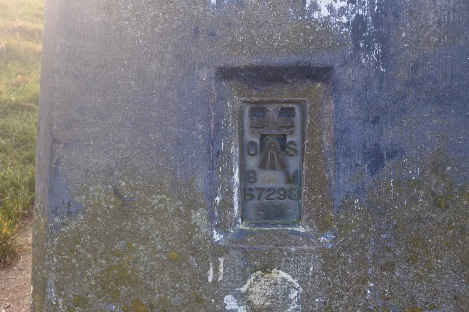
The "path" contours the west side of Bwrdd Arthur, or Arthur's Table. This is 164 metres high and there is evidence of prehistoric times and pre -Roman. When the path terminates at the road, look for the path which runs parallel with the road on the left and then heads uphill to reach the summit with its Trig Point and OS benchmark S7298. Hopefully the weather gives good views as it did for us.


Re-trace your steps back to the road corner. Take the road south, slightly uphill and then after 100 metres take the road right with the mast on your left marked Lon Goch on OS map. Head down the road with fantastic views in front showing you just how much height you gained from the car park.

At a large white stone on the right side marked Castell, carry straight on, on an old green lane. After a few hundred metres the track turns sharp left, at this point keep straight ahead down a narrower path which leads to a stone stairway and a metalled lane.


Turn left here with high hedges on both sides. At Hafod Wen the lane turns into a very wet and muddy path which in many places resembles a stream. Keep on this lane until you are faced by a fence with a small stile. Don't cross the fence but turn right on a good gravel track which leads to a farm Pen Rallt. At the farm follow the path round to the right, ignoring the Chelsea FC banner.
Go through the gate and join the road. Turn right, down hill passed Hafod-y-Rhug. and then at the footpath sign on the left turn down the lane.

It is a good track and when you see an old derelict building in front of you, look for a gate on the left. Go through the gate and once on the other side there are two paths. One on the level and the other, the left hand one goes uphill to some steps. Take the left hand one and follow it until it exits on a road.
Turn right here and follow the road downhill to the beach car park where you started.


Route is written in a clockwise direction from the car park P.
Distance 7.4km and 2hrs 20 mins with stops for photos.


Monday, December 23, 2019

Penmon, a castle, a lighthouse and a Priory and a walk of course.

The castle was just a short outing so I won't bore you with the details of the route. The castle called Castell Aberlleiniog was/is a Motte and Bailey type structure. It must have been a fine structure in its heyday. The motte is still deep and clearly defined although waterless. The castle walls are still visible but stand only a few feet high.
The 360 degree viewpoint would have been fantastic before the trees were allowed to grow too high.
It was built by Hugh d"Avranches between 1066 and 1099. He was the 1st Earl of Chester.


From here we headed off through the small and quiet village of Penmon. A staircase stile led us into what used to be Penmon Deer Park, formed by the Bulkeleys Family from Beaumaris. Today it was full of sheep and cows, not a deer in sight. It was a steady uphill walk following what looked like old Priory walls, far too elaborate and high to be farm fencing and obviously cost a fortune to keep the deer in.
An exposed limestone scar led to an elaborate kissing gate where we joined the Isle of Anglesey Coast path with its fine views across the Irish Sea. We followed the high wall which seemed to have been built on an old dyke. (my guess)
A good path joined a metalled track which we followed for a few hundred yards before realising we were heading in the wrong direction. We were going to the quarry instead of the lighthouse. Turning back we found our mistake, we should have crossed the metalled road instead of following it.
The right path gave us good views as we made our way down to Trwyn Du or Penmon Lighthouse.

There is a cafe but we picked the day it was closed, so no toilets either. It was bitterly cold but not too windy and I bet its a very busy spot in the summer. Plenty of signage told you what you couldn't do in the area so obviously visitors are tolerated rather than invited. If you drive up to the lighthouse then you have to pay a £3 toll to use the road. Reading some opinions about the toll a lot of folk are unhappy about it. We walked so we get there for free.

The lighthouse is in very good nick and very photogenic. It would be great to visit on a very rough day with waves crashing high up the tower.
Penmon Deer Park

Fancy gate out of the park.

 First view of the lighthouse and Puffin Island.


 There was a bell ringing, as you can see it on the right of the picture. First time I've seen a bell on a lighthouse.
Making a splash
Trinity lighthouse keepers cottages.
 The closed cafe. (we will make another visit)
 From the lighthouse the route back follows the toll road past Penmon Priory. We plan another trip to look around the Priory so I will not go into any details on this route.

Just passed the Priory we hit the beach with lots of bird life but not human. Many Oystercatchers and Green and Red shanks noisily finding food on the ebbing tide. I spotted a piece of pot in the muddy sand which I scraped out and found an intact Wm P Hartley Marmalade Jelly pot from around 1900.
That is going home with me.

Wm P Hartley Jelly jar.

Todays Route.


Tuesday, December 17, 2019

Strolling around Hodbarrow Nature Reserve at Haverigg

We were up in the Duddon Valley for a weekend, went out for a very nice meal at Da Vinci restaurant in Millom and helped put up the Christmas lights on the exterior of our friends house in Seathwaite.

The following morning we had to make a trip to Haverigg and so decided to enjoy a walk around the nature reserve and get some sea air.

I hadn't realised how much the static caravan site had grown and now was called Port Haverigg. It looked nice all the same, very clean and tidy. The last time I was here it was half the size.
There is also a site which will allow tents, called Harbour Lights camping. It seems that the minimum price is £23 per night but that is for a tent, 4 people and a car. They may allow backpackers to camp for less but it isn't advertised.

On our walk around and not far from the camp site is a very nice cafe/Band B called Herdwick's, which we had a look around and decided to partake in a brew. It's not huge inside and considering how busy this area would be in the summer its a good job they have a large outside seating area. Its worth a visit all the same.


View across the lagoon to Port Haverigg with Black Combe in the background.

There is plenty of industrial archeology in this area with the now closed iron works which at one time  produce high grade iron from the highest grade ore in the world. There can still be found large chunks of iron slag around the nature reserve.

The first structure we came to was the old Hodbarrow Haverigg lighthouse which is now just a historical landmark. It was built around 1905 by the owners of the iron works. It also built a large protective sea wall. The original lighthouse was built just a bit further around the lagoon also by the mining company which guided ships into the port. Built in 1866. The older lighthouse was abandoned and also the new one in 1949. It was rebuilt and re-lit in 2004 but today it looks abandoned again.
 Hodbarrow Light house. (click on the name for more info.)

 Commemorative stone on completion of the outer barrier wall.
It says:- Hodbarrow Mines
This block was laid
On the 13th April 1905
By
Harry Arnold Esq.
Chairman of the Hodbarrow Mining Company Limited
On the completion of
The Outer Barrier
Commenced April 1900


Iron Slag

Across the way, which is where the iron works stood, is the RSPB hide with its Tern Sanctuary.

Further on a second structure can be seen on a slight rise which does look like a collapsed lighthouse, it is very similar in shape to the folly in Ulverston. This is not a lighthouse but an old windmill called Towsey Hole Mill and ground grain, probably oats. It became an office for the iron works but was not in great condition when the works closed down.

There are many paths to chose from around the area of the old mill which includes a couple of picnic areas, an OS trig point and a nice beach. We had to met our friend Tina and so took the easy path around the shore of the lagoon where we passed a new stone pillar put in place by the RSPB, I am surmising.

Wind Mill (remains)

Today we had some clear skies with the Scafell and Coniston mountains covered in snow, it was looking great and I wished I was up there.

We walked past the original lighthouse, now derelict. It's a real shame that this cannot be put to some usefulness by the RSPB, it would make a great lookout and a hide could be built atop.

 Two shots of the original lighthouse.

RSPB standing stone.


All too soon we were back at the car where we met Tina. So a late lunch was called for and we headed of to the Beach Cafe at Silecroft.

 Silecroft Beach Cafe.

Terrific weather on Silecroft beach


Route 5.5km (Excludes route to Silecroft which was by car)


Thursday, December 12, 2019

Heversham Head

Setting off from home, it rained. All the way up the M6 to junction 36 it rained. Luckily traffic was quite calm.
It was close to lunch time so we decided to go to the cafe at Farleton Fly fishery. A bit of a hideaway place. It was shut and doesn't open until 5th March. Gutted.

We headed off down the very narrow lanes and looked for a parking place at Heversham village. Crickey they dont want visitors here, no official parking places as far as we could see.

We found a spot not far from the Church, on the main road. It was still raining, blowy and cold. Having donned our wet gear we found our way into the church which for a small village is huge and dates way back in time. We met a chap in there who could have been the warden and he told us of the route up to Haversham Head. That was where we were heading anyway but it was a pleasant chat.


Haversham Church
St Oswald Windows. 
There is a good path through the church yard, passing some very big and obviously expensive grave stones. We love looking at the history in church yards.
Anyway it wasn't a nice enough day to dawdle so upwards we went. The route is obvious until you leave the last of the houses and then I guess there has been some new fencing put up. Fortunately we found a gate through to the field which has a viewing point and a trig point. The route is not shown on the OS map.

 OS trig Point on Haversham Head

The views on a good day would be wonderful but today was not that day. The mist and rain had put paid to that. But it was good to be out anyway. 
From the trig point we could see a rugby playing field and our route went through it so it was an easy downhill walk back off the top. We picked up the old railway line path which is not shown as a path on OS map but it is permissive. We followed it back until we came to a road bridge and steps up to it. There were many houses to admire and we were soon back at the car.


Find it Here

About Me

My other blog. beneathwhosefeet.wordpress.com