The Vault Regulars

Sunday, November 24, 2019

Topo Hydraventure 2 Trail shoes first review.

"Topo", if you didn't know, is the name of the guy who owns the company. Tony Post. The company, Topo Athletic is a young company from the US and was founded in 2013.


I bought these for £125 from Castleberg Outdoors in Settle. 
First thoughts, very very light. very smart.
Weight size UK8 mens. (My scales) 644 grams per pair. Company bumf says 564 grams so there is a big discrepancy there. They are still very light but the info provided should be correct.

Waterproof with eVent lining, The eVent is bonded to the outer fabric so there is only one seam on the shoe and that runs up the heel. I would suggest that the use of insoles such as "Superfeet"would cause the event to cut. So not recommended to change to that type of insole. The supplied footbed is really comfy anyway.

The tongue is gusseted to stop water and soil ingress and to reduce pressure on top of the foot.

Sole is Vibram Megagrip with 4mm lugs.

Upper, is single piece laminated with breathable mesh panels. No stitching to come undone.

The mid sole is the usual EVA type but this has a built in rock guard which protects the sole of the foot when walking or running on hard ground. If you have ever used a deep lugged shoe then you will know how painful it can become.
Sole wraps up the front of the toe box.

The drop from front to back is 3mm. The front measures 20mm and the rear 23mm. The heel is stiffly supported to prevent the foot rocking and maintaining stablility.

Good quality laces. Stay tight.

Very roomy toe box. I would suggest that folk who have a narrow foot buy with care. I consider i have a wide foot and there is still plenty of room. In fact i might start wearing Injinji socks.

My first 20km in them haven't thrown up any issues to the negative in fact the main things, comfort, waterproofness and grip have proved excellent. But, just like wearing a waterproof jacket all day you will find that the sweat your feet generate can make your socks damp although you don't feel it during use. I don't mean wet, just damp.

There are lugs on the back of the heel which are there to take the Topo short gaiter, made especially for this shoe and cost around £14-£15.

The material is very easy to clean and the company also supply a spare pair of laces in the box.

Thats my first impression after 20km. I will report back after 200km.


Friday, November 22, 2019

Settle outing. (circular)

I didn't have a particular good night, so I wasn't in a great frame of mind. I more or less skipped breakfast, having just a few cornflakes and a small fruit salad. Although there was a full English Breakfast on offer I gave it a miss. Not like me at all.

Yesterday I bought a pair of Topo Hydroventure 2 trail shoes from Castleberg Outdoors in Settle Village, a specialist outdoor retailer of some 32 years. They have a terrific range of shoes and boots as well as much more and leaves the "bigger" shops of Manchester standing and I was pleased with the service and expertise given by Catherine.

Armed with my new shoes on, we set off on a walk which would give me a good first impression of their performance. It was a cold windy day but dry if a little dull and overcast.

The first 500 metres or so was on public highway, hard underfoot. Sometimes with deep lugs on trail shoes you can feel every step but these were fine with good grip as well.

We passed underneath the railway bridge and turned towards the river when we reached Runley Mill. The mill is now converted into houses but you can still see signs of its previous life which goes back centuries. It was mentioned in the Doomsday Book. There was a lovely Border Collie sat astride a quad bike looking like it was riding it. Her name was Jess and very friendly.

Reaching the river a gate leads up to the main road, the A65, and crosses the river to a path along the opposite bank. It's a decent path which follows the river bank to just beyond Brigholme Barn where the path cuts diagonally across the field to a style at the B road. Across the road the route is along a narrow walkway leading through a small housing complex and exits again at the river bank.

For a little while a domed structure could be seen on the hillside and then just beyond the houses we had a really good view of this fine structure. We didn't know what it was so we spoke to a local dog walker who told us it was Giggleswick School. It was established in the town in 1499 but moved to its present location on the hill in 1867 when the dome was part of the building plans. It used to be a bright copper colour but today its colour is a dull grey.
 No Bull, Oh yes it is.

The Domed School on the horizon

Let me out.
Many signs of old Settle mills adorn the river bank and most have been turned into smart apartments, they look good. The sounds of Mallard followed us but we didn't see many more water birds except a Heron.

Just beyond a modern footbridge across the river and into the village was a natural weir ,which gave us a photo opportunity. The next bridge which has the B6480 running over it was where we left the river bank. We took a few photos from varying angles and whist doing this we spotted a large waterwheel at the rear of Bridge Mill. This was very interesting as was the weir and water race. A few guys were working to clean up the area and we were allowed to have a look inside the hydro electricity generating station. Its only small but it was immaculate and generated 240 kilowatts. It provided power to the apartments at Bridge Mill and the remainder is sold into the national grid.

 A "stylish" footpath bench
 The weir at Bridge Mill

The wheel at Bridge Mill, it must have generated lots of power.
The Hydro race.

After a short walk through the village we visited the local church with its large cemetery and then returned to the route past the Folley Museum of North Craven Life. We called in and had a very interesting hour. A bit pricey to go in we thought at £8, but if it goes towards the maintenance of the building then it was worth every penny.
 The Folley Museum


 I took many photos inside the museum but i like the two below best.


Onwards, down the road past some wonderful old cottages towards the Library. We took a left along Brockhole Lane. An old green lane which in parts is also a river bed. Some great views of Kirkby Fell, Rye Loaf hill and the rest of the ridge to the north and Hunter Bark to the east.


 Looking back to Settle
 How Much! Yar in Yokshur Lad.
Yorkshire Autumn
It was turning into a nice day with plenty of blue sky but still a biting cold wind. On reaching the lodge road at Hoyman Laithe, we turn right and head back to the main road which brought us easily back to the car. (Laithe means either granary or barn)


The shoes, yes, more later.


Sunday, November 17, 2019

Forest of Bowland walk from Browsholme.

We decided to have a couple of days away and try to make a start at going somewhere new with a walk included. A bit of a plan, if an easy one.
We didn't want to go far, so after a few days on the internet we decided to go clamping. A midway point between camping and a hotel room. We booked a pod at Browsholme Hall, pronounced "Brusum".
Browsholme Hall

The hall is a spectacular building open to the public during the summer but unfortunately its closed now for the winter. It's been in the Parker family for over 500 years and they still have it. Quite amazing when you consider the history that it has seen.

There are 10 pods and we were the only folk there. It was our first go at Glamping and though these were quite expensive pods in comparison to others we had read about, they were very comfortable.

The grounds of the hall are extensive and we asked about walking round them and were told we could go anywhere. We only had a couple of hours daylight left so we made the most of it.

In the evening, without a TV and internet we looked at the map and chose a route to walk. I was still a little anxious which is strange because I knew this was an easy plan but its all part of the re-training.

It was cold overnight but the morning was clear and windless. We set off straight from the pod, walking north from Browsholme Farm and up hill towards Spire Farm. Every now and then we would stop and look back, there are good views across to Blackburn and Preston. The tops of the hills were a bit misty and cloud inversions covered the valleys.

We were on a good path, well that was until we got to a small marshy pond, south of Spire when it all changed. All the way to Spire was a mud fest, knee deep in parts, boggy, tussocks of bog weed and it was hard work.
Spire is a strange building, I think it belongs to the Browsholme Estate, it has a castellated tower, a bell, and sun and moon symbols in the gable end. What it was built for I'm not sure. The local story is that it had something to do with hunting on the moor in bad weather, so you could find your way.
 Looking back towards where we started.  The aptly named Longridge in the distance.


 Spire Farm

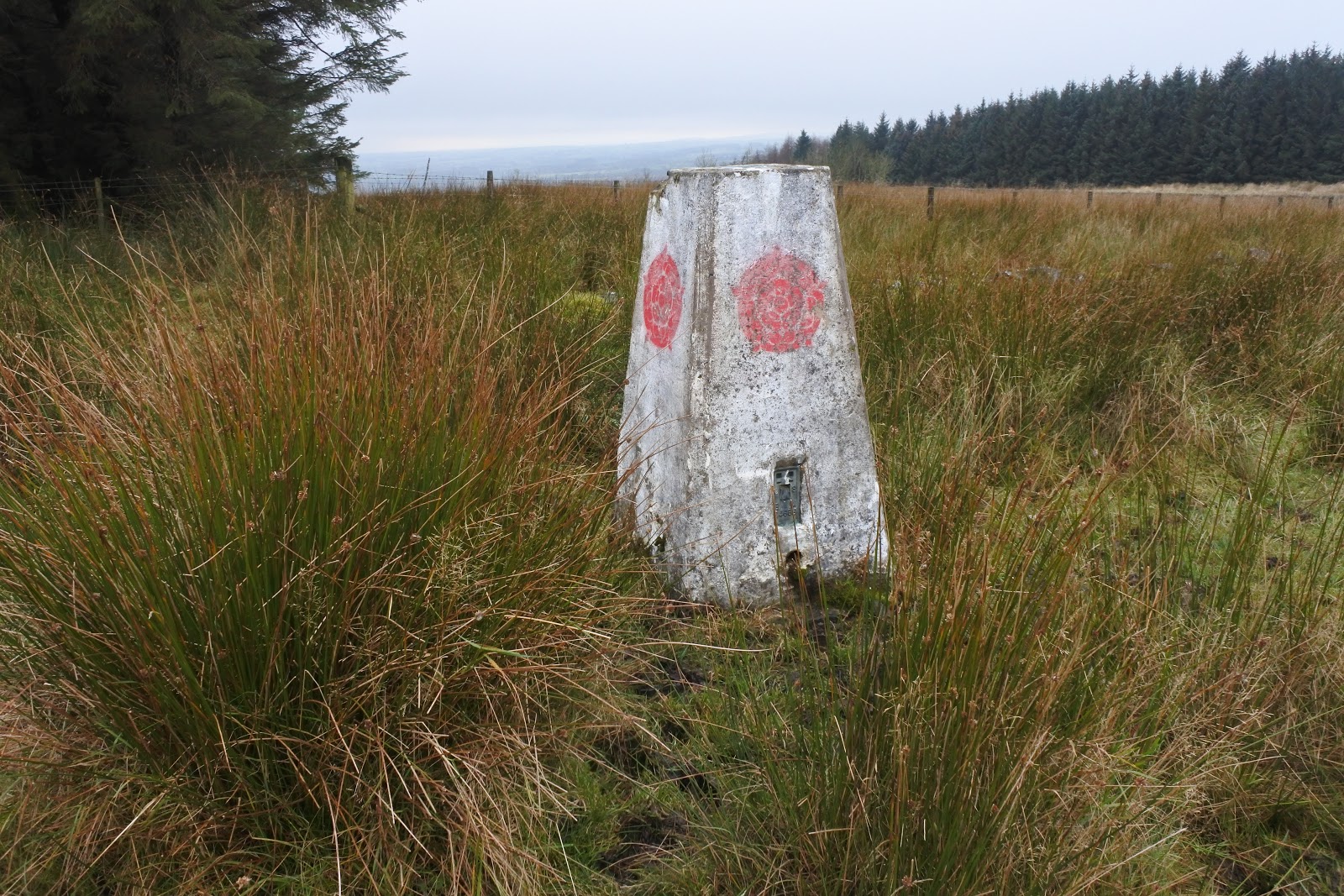
Reaching solid ground of the farm access road we headed for the trig point. Unusual again, it had a Lancashire Rose on all sides. We had to retrace our steps back towards the farm to pick up the footpath going north and heading to the moorland road near Crimpton.

Trig Point and OS benchmark S4665, Grid Ref. SD 6801 4666

With hindsight we didn't need to retrace or steps really because there was no path, just more bog and mud. Entering a small coppice and following a stream to the road the ground was just like a black sponge, reminiscent of kinder scout. It was awful and on numerous occasions we went right down in the goo. Luckily we kept our footwear on.

At the road we met a couple of walkers heading onto the moor towards Crag Stones. They enquired about the path conditions we had been on, they said its always been bad and the path past Crimpton was no better. At that point I was in a laughing mood.

There is a path diversion around Crimpton Farm which also does B and B although it isn't advertised for some reason. The path was ok and the views were good on an improving day.
Beyond the farm a stile gives entry to woodland and it was here that the path deteriorated again to great swaths of downed trees and deep muddy holes. I was glad to get out of the woods and over another stile into an open field but just as squelchy.
 Looking North from Crimpton Farm
The footpath beyond Crimpton.

A large rambling group was encountered at the stile near Raven Scar plantation. We waited until they all cleared then made our own way through. The route crossed the road and headed down to the Inn at Whitewell, a fantastic old inn with wonderful food but not cheap, you get what you pay for though. We headed upward past an old quarry and what looked like a lime kiln. The views had improved so much and all the tops were now clear as was the whole of the Hodder Valley.

 Fast flowing River Hodder at Whitewell.
 Inn at Whitewell
Looking back down to Whitewell
Another muddy route brought us to Higher Top Barn with its expensive ornate gates and stiles. There were many pheasants here as there are all over this area. We found a place on the wall to sit down and have a coffee and took in the scenery for 10 minutes. This place must have been owned by a rich landowner years ago. Probably the barn belongs to the farm Radholme Laund which is steeped in history, hunting, forestry etc.
 Looking over to Totteridge.
 Burholme Bridge with Mellor Knoll beyond.
 Zoom shot of the bridge

 Fancy Gates at Higher Top Barn.

As we dropped down hill towards the farm I decided I had done enough and cut short our route. I checked the map and although the farm access road is not a public footpath we decided it was the quickest way back and so set off.
Just as we reached the end of the track the farmer stopped in his land rover, wound down his window and asked if we were lost as his road was not a public right of way. I apologised and said that we were not lost but knackered and took the quickest and easiest way back to Browsholme. He had a good laugh and chatted to us for about 5 minutes about the clamping pods and about access and camping in the area. (There's no camping around here).

Once back at the pod I think I slept most of the late afternoon. The walk was only about 10km but it was tiring walking in knee deep mud and heavy wet grass.
 It was good to be out all the same. Onwards and upwards.

Awful paths marked A to B and C to D on the map.


Find it Here

About Me

My other blog. beneathwhosefeet.wordpress.com