8th September 2023
On this humid and overcast day I thought we would do a bit of a hill. I hadn’t picked a complete days route before we set off but I had looked at the map for a way up to the trig point and Haume Beacon. High Haume has quite a bit of history that isn’t particularly obvious. It was a hill fort with a fosse no less, it was a medieval beacon and later it had lime kilns. It lies to the south of Cumbria in the outlying hills, north of Barrow in Furness. Probably one of the "fells" frequently overlooked except for the locals and the trig point baggers.
A quick walk along Askam’s Lots Rd brought us to the A595. This is the main road into Barrow and is a fast and busy road to cross. We waited for our chance then dashed across to the cycle way/walkway where we nearly got knocked down by a bike. That would have been ironic, but we survived.
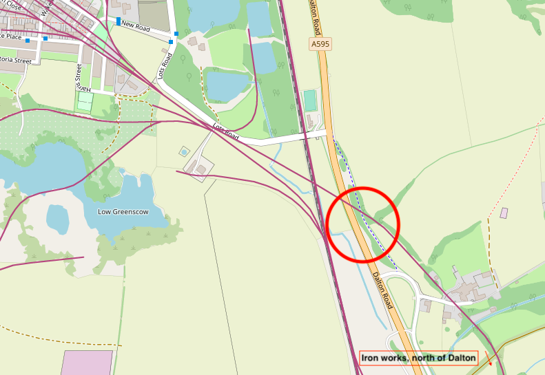
Not far down the trail we came across an old high brick wall. Standing back it looked very much like an old railway bridge and in fact the cycle way looked as though it could have been a railway also, but it was narrow, so maybe an old tramway. Something to investigate later. **
The curious brick wall.
**Within the red circle, the blue dotted line is the footpath we are on and not a tramway as I had thought, and the purple line is the old railway line which went from the numerous iron works just north of Dalton, to the furnaces in Askam and then through to Askam Pier. The bridge parapet is a remnant of that old line and would have closed in the 1930's..
My route left the track as we reached the old main road and we took a left passing Greenscoe farm. We were greeted by two goats, a dead rat and a lovely grey cat who wanted to walk the route with us. A gent sitting in a large window with views looking over the Duddon Estuary gave us a friendly wave as we passed.
The metalled lane soon became a land rover track and then as we gained height into what must have been a very old green lane. A footpath on the left had a fine gate and this would have been the main path for the workers coming from Ireleth many years ago.
Medic!
Our view today would be very different to what those workers would have seen a hundred yrs ago. It is very hard to even imagine. Surrounded by industry and chimneys, quarries, iron works, railways everywhere, blast furness's, lime kilns, brick works, smoke and noise.
The end of the metalled track and start of the green lane.
The view from the green lane today. (I wish I could find one from 100yrs ago as comparison)
At the end of the green lane we exit onto a fairly quiet fell road, no footpaths but we only had to walk 100 metres or so before a stile is reached back into farm land. Sticking to the right fence line and following a narrow path we had to seek out a couple of hidden stiles which brought us adjacent to the trig point. The trig point is on private land, there is no public right of way shown on the map. However it is close to the footpath and I think many locals use this route. We headed up to the trig point and then along the short ridge line to the "Beacon".
There isn't much to see today, an obvious hollow with surrounding mound.
Then it started to rain and we didn't bring waterproofs as rain was not forecast. But it didn't matter as it only lasted 5 minutes.
One of the stiles we had to search out.
Askam Brick works, still in use today.
Almost at the trig point.
Flush bracket S5373. Bagged!
Some of the heavyweight watchers as we headed for the Beacon.
Stood on the remains of the hill fort, beacon and lime kiln!
To rejoin the right of way we headed off diagonally towards the telecoms mast where a gate was. In the way was another couple of heavyweights. One with no head so it seemed.
Big lad. Gave us no trouble.
The view from the telecoms mast and our route down towards a road in the centre of the photo.
A stile no longer in use.
A stile which was passable today because of the fine weather but it would be a sinking feeling in wet weather. The cows had made a good impression.
The stile led to the A595 road which we crossed quickly again and walked through the pleasant village of Greenhaume. At a bench on the cycle/walkway we stopped for lunch adjacent to a bike fixing station. I had to have a look at what tools had been provided which inadvertently caused me to have a sore head as I bashed it on the 2 bars protruding from the top of the post. The bike pump was sadly missing, presumed stolen.
The bench badge which I assume to be Furness Abbey and a way mark of some route.
From the Bench and through a gate we headed towards the lake in view. At this point I hadn't the slightest idea where I was going or which route we were going to take. We had gone as far as I had "Planned" yesterday.
Through a very strange gate led us into farmland above the ponds of Park Farm. We stopped at the fence and pondered about where to go now. I knew we had to head off towards Black Combe but getting there took a bit of studying.
We took some time studying the map. A path went in front of Park farm then through he brick company which led to the A595. I didn't fancy that route but I wouldn't have minded having a look at Park Farm which looked very interesting from our high perch.
We decided to head south, follow the railway line towards "Thwaite" and the Dunes Hotel, then head towards Roanhead where I knew a path to get us back to Askam.
A good track through sheep territory brought us out onto Park Farm road where Postman Pat passed us as he was to do numerous times over the next 45 minutes. The road is very quiet and we only saw one car. Then the noise grew louder as we passed under the A595 road bringing us to a level crossing. The signal box says South Park or was it Park South?
The lovely signal box was built in 1883 and all the interior mechanism, 17 levers, came from the Coniston signal box in 1962 when the Coniston line shut.
We crossed the level crossing and then had a pleasant country lane walk passed the unaptly named Dunes Hotel, neither in the dunes or on the coast. The hedgerows provided lots to look at and berries to eat.
A short distance from the level crossing we had to cross the A590 which we timed just right as it wasn't busy.
The Dunes Hotel.
A Matbro teleram 40 handler. Pivot steer and dates from around 1983. Looked like it had a Ford engine in it.
A stile I wasn't going to try and get through.
Meadowsweet.
No description required.
Blackthorn.
Hawthorn
A Grizzled Skipper.
We were now back to a track I knew. It is a permitted path and leads through the working farm of Roanhead. Thanks to the owners for allowing walkers to use this lovely route.
The path to Roanhead Farm
If only cameras could smell how wonderful this log store was.
I saw a tractor I had never heard of, but there again Chinese tractors are not popular in UK. Most are auctioned in Europe.
This one is a Luzhong 404. Hands up all those that have heard of it?
The path through to Askam is a fine route and it used to be the old Mineral Railway. Below can be seen how farmers used the remains.
A much longer day and post than I originally thought. I hope it isn't boring.
Here is the route we eventually trod. 12km.


Plenty to go at in that region. Thst tractor has impressive front tyres.
ReplyDeleteIt’s a good place to start the Cumbria Way if you didn’t want to go to Ulverston. Loads of good walks.
DeleteThe blue tractor wheels are 4WD. For a small tractor it can still fit a loader and a small digger on the back. Cheap machines which are said to be reliable but spares are hard to come by. For me, I would have bought a Kubota.
"Hello, I'll be dead if you tread on me" said the about to be trodden on rat.....
ReplyDeleteIs that from Monty Python or the Pied Piper of Timperley?
DeleteMonty, the Pied Rat, I think...
ReplyDeleteHa, It definitely wouldn't rise to the tune anyway.
ReplyDelete