The Vault Regulars

Sunday, April 9, 2017

Measand Beck to Small Water, backpack day 2.

The day started with a wake up call from Sheila at about 6.30am. The sun 's up she said. I'm not I said. But it didn't matter, once Sheila's up that's it. The trouble is her normal get up time is around 5.30am whereas mine is, well much later.
The sun was up but it wasn't great as sunrises go, the cloud was all wrong. It was warm though, and very still.

I got a brew going whilst still in my sleeping bag, and then decided it was too nice outside and so clambered over the stove, tripping and knocking it all over. Very, very lucky that the near boiling water went under the tent and not in it and also the meths was just about to burn dry. A lucky escape and a mental note made not to do it again.

Packing up the tent was a delight as it was perfectly dry and no condensation to wipe up. The day perfect, blue sky, almost cloudless and still. We set off at 9.15.

Crossing the bridge over Measand Beck the map shows a good path inclining left up onto Low Kop.
The map doesn't show the path made by quad bikes which goes slightly right from the bridge along the original footpath from Measand End to Four Stones Hill and swings left passing the old quarry.
However the inclining path does not exist on the ground, we used GPS to pin point where it should be and made our way up what is very steep and very rough ground. We eventually joined up with the quad bike track just before Low Kop.
The track then is extremely boggy all the way to High Kop and Wether Hill.
 Time for Breakfast
 Approaching the bridge over Measand Beck on a perfect day.
 The higher reaches from Skreel Side with some nice camp spots.

Quad bike erosion, all too much of it. This is High Kop looking towards Wether Hill.

  Once we hit Wether Hill and the watershed down to Martindale the views were stunning. We were so lucky. We saw our first soul here, a young lad jogging. Then 2 ladies fell running and a solo chat with a hellish pace on him. 

 The High Street path, an old Roman Road linking the forts of Brougham near Penrith with Ambleside is 2000 years old and is in bad shape, very boggy. I doubt the Roman Emperor would be
happy with it today. 
The rise up from Wether Hill to Red Crag and then to Raise is a long steady climb, good for getting the legs working.
The views are so good it needed a better camera than i had to really pick out the detail.
 Views from Red Crag of the Helvellyn Range.
Skylarks were following us and their cheery song enhanced the day. Reaching Raise had us stopping for a drink, it was really warming up nicely. Within 5 minutes of us reaching Raise, about 10 people came and went with a quick hello, nice day.
I pointed out Kidsty Pike to Sheila as from Raise it looks nothing and getting to the cairn is an easy plod. High Street on the other hand looks enormous, that great whale back of a hill filling the foreground. How they ever managed to run horses here is amazing. 
View from Raise looking west.
 Kidsty Pike, left. High Street beyond.
 High Street from Kidsty Pike.
 Kidsty Pike from a more impressive angle
 Approaching High Street
Wonderful view down Riggindale

 We followed the wall up to the summit of High Street, passing numbers of people going both ways. Dogs barking, phones ringing, it was like being in Manchester. So busy. 
It's a hard pull up to the trig point, which we did in sections of 40 steps, then stop, etc etc.
Getting to the summit meant more people, more dogs, more phones. We enjoyed a few minutes looking at the panorama of mountains and then moved off for Mardale Ill Bell.
 High Street Trig point. 828 Metres.
 View west from High Street.

 On the new path to Mardale Ill Bell.
View south from Mardale Ill Bell. Frostwick, Ill Bell and Yoke at the back.

 The path down to Nan Bield Pass is in good order and the crowds were starting to thin out. There are so many routes to get up onto High Street. The wind started to pick up and it was getting a touch chilly. Not complaining though, it was still a gorgeous day.
 Mardale Ill Bell top with Haweswater behind.
At Nan Bield Pass with our overnight destination in sight. Small Water.

 The pass has been improved since the last time i was here, it must have taken months to get all the stones in place. Great job.
A lady and i assume daughter stopped us for a chat. Nobody else had packs as large as ours. All day walkers. She lived in Askham, which is a nice place to live with lots of walking options. 

Down at Small Water we made our way around to the east side where a good green patch had looked inviting on our descent. It proved to be an ok spot. We brewed up and then got the tent up to get out of the wind. 
Camp spot to the right of small water where the sun is shinning.
I was close to having a swim but changed my mind once i got my feet into the water. It was a bit chilly to say the least. I settled just for a wash.
Tea was nice, we had Chicken Biryani and Morrocan Cous Cous with Chicken from Food on the Move. Both meals really tasty and can recommend them. Then for afters we had Birds Custard. great camping food.
We didn't get much of a sunset but the wind had picked up quite a bit, as it stated to get dark the temperature plummeted with the clear sky's. It was bed time.
 Overnight spot. Leave no trace camping.
A bit nippy for a swim.
 Wind picking up.

Our Route day 2.

Thursday, April 6, 2017

Swindale to Haweswater. Backpack day1.

After a cracking breakfast in The Abbey Cafe on the main street in Shap we made our way to Swindale, the start of what was hoped to be a leisurely 3 day backpack.

Swindale is now a quiet Cumbrian valley, a little bit like "the place that time forgot". You cannot drive down the dead end road anymore and in some ways this adds a charm to the place. If you want to walk the fells beyond Swindale Head then you have a fair walk to get to the start.

We however, were heading for an overnight camp somewhere along Measand Beck on the west side of Haweswater leaving the walk down Swindale for our return leg.

It was raining, of course it was, Sheila and I were out walking, so it was bound to rain. It had been raining since before we left the motorway on the way up.
We sat in the car at the said parking spot and watched the outside world come and go in the mist. A few sighs and a realisation that this rain was no shower made the decision that we might as well get going.

We had a few new pieces of kit to try out, for starters Sheila had her new over trousers, the right leg length this time, a new shell jacket a pair of trail shoes, an iPhone charger and rucksack. I had a new rucksack, a pair of over trousers and a water filter to try.

Our path started at NY521141 and it was more like a stream than a path, very slippery in places but otherwise clear.
 The start, Swindale
Clear did i say, well it was clear until it disappeared on the ground at around 300 metres and then joined lots of paths not marked on the map. We stood atop an outcrop and surveyed the many routes.
As we were in no rush we decided to head up or along to Scalebarrow Tarn but it wasn't anything to shout about so headed back on track to the gate in the wall.
Heading for Scalebarrow Tarn.
From the wall, the route down to Naddle Farm is a pleasant one, even in the rain, many deciduous trees line the route and also the views start to open up to Haweswater. As we chatted i spotted movement out of the corner of my eye, it was a Red Squirrel. It stayed still on a bough and i had time to get the camera out. It was a bit far away and the camera doesn't have a view finder so i pointed, zoomed and shot. The result is far from great but at least i got a picture.

Across the ford my map reader said we need to take a left just past the buildings but we couldn't find a path. Naddle Farm is now the home of the RSPB and what a delightful place, however, re-checking the map the route definitely shows a left turn between the buildings, so back we went and found our gate nicely hidden from view by a very large trailer and a load of fence posts. Squeezing past we just about opened the gate to get through.
Boy was it a boggy path. It leads to the Haweswater - Mardale road where we were hoping to cross over the dam outflow by a bridge marked on the map.
The problem was that nobody had told the Waterboard that we wanted to go that way and the gate was locked, the deer fence high and rickety and the path a bit overgrown and unused. We made our way to the Dam end but again progress was blocked with chains and padlocks.

 The road back down towards Bampton was our only way to get across to the other side of the dam. The good thing was that whilst looking over the surrounding walls we spotted a Deer. Was the Deer fence there to keep them in or to keep them out? I guess the later and obviously it wasn't working.

At the bridge over Haweswater Beck a finger post and footpath leads into Burnbanks and so saved us a longer road walk. The path is a good one, lots of fungi and birdlife.
Haweswater Beck at Naddle Bridge.
Burnbanks is a non descript sort of place with nothing to keep you there. I suppose its a very nice place to live though as long as the dam holds. I wonder what the house insurance costs. Anyway i digress. 

Through Burnbanks it only takes a few minutes before your on the reservoir footpath proper. A very well made cast iron sign indicates the way. The rain was now intermittent but the path was still flooded meaning that waterproof gear would have to stay on a bit longer. 
The last time i walked this path was when i did the Coast to Coast but in the opposite direction.

Here we met the only people to be seen today, 2 ladies doing the circular route whilst the men folk did the high level option. The rain stopped, the path improved, at last waterproofs were removed. 
Blue sky started to appear and the atmosphere improved too. Its amazing what a bit of sun does for your well being. 

Before getting to Measand Beck we could hear the force of the water. We were lucky that it had rained so much, the force was with us. It's a truly wonderful Beck with many falls throughout it's length and a worthy walk to do it end to end. 
I have walked it before but it was many years ago, i didn't keep records then so i guess it must be 30 years ago. 

We were wild camping,  spending the night here or there abouts and i had a good grid ref. given to me by fellow backpacker and blogger Robin. Thanks ever so much. We went to have a look at the spot but decided that because of the good weather forecast we would prefer a view of the reservoir, especially hoping for a good sunset or sunrise being projected onto the water. 
We picked a good spot, i will email the GR if anyone is interested. (Al, you know where we mean)

 Reservoir track and the rain has stopped.
 Tail of Measand Beck
 Stopping Point with a view.
First job after getting the tent up was collecting and filtering water. I was trying the Soldier Filter for the first time in anger. I have to say its the worst filter i have ever used, almost useless, definitely hopeless for a backpackers needs. 
The outlet pipe that is connected to a plastic elbow which then fits into the body of the filter continuously falls out. Can be easily dropped into the water. The filter body has to be perfectly upright to pump the water through otherwise it lets air into the system.
I cannot get close to recommending anyone buy this. So it was back to my old reliable Delios.
 Late afternoon sunshine.

Dusk and getting cold. 
Food wise, for this evenings meal we had wet food which we needed to use as it's best before date had past. Pasta Bolognese. It filled a space, thats about it. 
The evening was leisurely, doing a crossword, drinking coffee and thoroughly enjoying the peace and quiet, the views to die for and the calm windless evening with no midges.
The lights came on in Bampton and the Haweswater Hotel. It was time for bed and looking forward to tomorrow.

Our route, day 1. Not long, just 7.5km with 304m of Ascent.
The knee did good which was a bonus.

Friday, March 24, 2017

Bergan's Women's Super Lett Overtrousers - FOR SALE

A pair of quality over trousers for sale. Bergan's of Norway, Women's Super Lett. Size 10.
These are Sheila's which she bought in November 2016 from The Cotswold Shop.
They are currently on sale for £110 because they are more than likely down to their last stock.
Sheila paid £130.

Reason for sale is that they are too long in the leg for her, they are "regular" length whereas Sheila is short leg. (Don't ask me why she bought the wrong leg length).

Anyway she has worn them on 2 weekends only. They are made from 3 layer Dermizax material from the Japanese company Toray.
Dermizax is not overly common in the UK although it is used by top brands.
  They have side zips up to the knee, a waist belt a zip fly and press stud closure.

There is absolutely nothing wrong with them.
They are now hanging in the wardrobe and will not be used again as she has bought a short leg pair.

So if anyone is interested in a bargain she will let them go for £55,  reduced now £45, which includes P and P to anywhere in the UK.
Any questions, don't hesitate to ask.


Saturday, March 18, 2017

Cyber attacks Pt2.- an Answer.

My last post which was a general question about cyber attacks after the ABTA hack, from somebody who knows nothing about the subject.
It created a lot of blog hits but not much in the way of comments. I can only assume from this that i am not alone in lacking any sort of competence to the subject.

However, i have received an email from a person in the know. A person involved in the good side of all things shrouded in grey matter.
I have asked if the person minded if i posted the email on the blog because it explains not only the pitfalls of my initial question but also makes it clear that it is imperative to have the best security on your systems and your devices that you can have.

So i thank the person for taking the time to initially read my first post and to put such a comprehensive answer together. It makes things clearer if still a bit scary.
Here is the email in full.
----------------

It's good to be questioning everything when it comes to security*.

The short, glib, response to this query is that there is no such thing as an absolutely secure device if it is connected to the outside world. Perhaps not even then (as suggested by leaks and rumours about the NSA's capabilities.)


The ABTA attack appears to be relatively minor (I can say that, I'm not one of the 43,000 customers!) and on the face of it their website *might* have an increased "attack surface" due to the number of plugins and modules that are used to provide different bits of functionality on the site.  I say might because it would take a detailed analysis to say for certain.  The developers of the ABTA site probably considered themselves to be better placed than many websites because they aren't (well, don't appear to be) using one of the more popular website systems.  


The popular systems are popular because they are easy to use, thus lowering the barrier to entry for anyone to have a good looking site.  "It's simple.  I'll just grab this plugin for this function from here, that plugin from over there lets me have fancy emojis, and everything will be fine." Security can be a problem in these systems because of that popularity as most people do not put any thought into security (including some plugin developers) and users and administrators often choose weak or default passwords.  I have not looked into the cause of the ABTA breach so I am not suggesting that these particular attack vectors were used in this instance.  Website security is an ongoing process of adapting to known weaknesses and attack vectors.


Turning to the query in focus here, I am not sure what you mean by:


I got to thinking that if the software company provides "parcels of encrypted data" that can be given to individual customers when they decide to sign up with the organisation, the customer can then add data into specified blank areas which will then make that parcel a unique gateway.

So, if the main organisation is hacked then the amount of gateways opened would be minor in comparison to 43,000.


It sounds like you are suggesting the use of public key cryptography. This is a very useful and powerful way to secure personal data. 

Essentially every customer would create (or already possess) a pair of encryption keys.  These are known as the private key (which is retained and never published by the "customer") and the public key (the public keys are generally published somewhere).  

When Trump wants to send a message to Putin that he wants to ensure only Putin can read, he encrypts his message with the PUBLIC key of Putin. Putin then uses his PRIVATE key to decrypt the data or message.  Similarly when Putin replies he will encrypt his response using Trump's PUBLIC key. (This is of course a fanciful and probably theoretical example.)

This page explains it well: https://www.comodo.com/resources/small-business/digital-certtrmrificates2.php

It's an excellent system but the overheads in training people how to use it properly, and the time it takes to encrypt/decrypt data, means that Mr Joe Citizen probably won't understand it or will very quickly decide that it's simply not worth the effort.

This is particularly so if such a system were to be implemented on a website - the computational power required for encrypting and decrypting is relatively large and the cost of doing something like this can be very significant. By way of example, law enforcement and intelligence agencies, and even data recovery companies, sometimes use hundreds of computers linked together to help crack document passwords which are significantly easier to crack than public key encryption.  The larger agencies utilise supercomputers and purpose-built systems for this purpose. 

Implementing public key encryption on a "normal" business website is not practical with current technology unfortunately.  The risks in an increasingly online and interconnected world are significant but so are the benefits.  From the end-users perspective, the best security advice is to try to only deal with reputable websites that implement *appropriate* security,  to use strong and unique passwords for each website (yes, easier said than done) and to ensure their own device and network are protected.  Administrators and developers have an obligation (in my opinion) to keep abreast of security developments.

*If you're in a corporate environment be mindful that you have likely agreed to not test security!  

Suggested reading:

Troy Hunt's excellent website: https://haveibeenpwned.com/ 
Public key encryption: https://www.comodo.com/resources/small-business/digital-certtrmrificates2.php
Top ten website application risks: https://www.owasp.org/index.php/Category:OWASP_Top_Ten_Project

Thursday, March 16, 2017

Cyber attacks- general question.

I would not normally put this sort of post on my blog as it is more to do with outdoors, but sometimes i need to know a little more and there are far smarter people out there than i when it comes to IT and programming.

The recent cyber attacks on ABTA organisation had me thinking.
Now i guess ABTA have bought expensive anti attack software from a company which will defend its data in a certain way. So if someone has managed to hack into that software it then has access to 43,000 personal files. (TV news).

I got to thinking that if the software company provides "parcels of encrypted data" that can be given to individual customers when they decide to sign up with the organisation, the customer can then add data into specified blank areas which will then make that parcel a unique gateway.

So, if the main organisation is hacked then the amount of gateways opened would be minor in comparison to 43,000.

Does this make sense to anyone? Or am i being stupid.(You don't need to answer the last bit.)

Sunday, March 5, 2017

Spring arrives, but just for one day.

What a difference a week makes. Today it was tee shirt weather. Forecast for rest of the week is poor.
But it was so good to feel some heat from the sun.


Photos taken with iphone 6.


Monday, February 27, 2017

A Howgill bimble

Sheila and i booked a weekend away in Sedbergh in the hope of doing some of the Howgill tops. Its an area we have been to before but barely scratched the surface.
The trouble with pre-booking accommodation is that you use it or loose it whatever the weather.
So with a dreadful forecast we set off. See below what MWIS had to say.

Of all the days to pick but we had to make the most it. Lying in our pit with the blinds open we could see some of Winder 473 metres and little else. The hill fog was summersaulting down the hillside as it would and the rain was sweeping across like vertical blinds.

I wasn't too happy as i was hoping for decent views. I'm not a big fan of walking in continuous mizzle having spent all that energy to get up high.

We decided that a good way to start would be to follow the path along the west side of Settlebeck Gill and hopefully the water would be in spate which would provide us with a view.
Walking first through Sedbergh village the cafe's were doing a good trade but it was quiet otherwise.
The rain was heavy and puddles deep.

It didn't take long for me to realise that putting my old Buffalo jacket on and then a waterproof was a big mistake. I was miles too hot. Then i realised i had also left the goggles and the camera on the table and also the coffeemate for the pre-prepared flask of black coffee. I wasn't in a good mood and pretty annoyed with myself.
At the end of Joss Lane the open fellside is reached and the route is also the Dales High Way, a route I have always fancied doing but never have, so far.

The ground heavily waterlogged and very slippery, the paths now running like streams. Through an old steel gate we got our first view of the gill coming down off the fell. It was indeed fast and wild water.
Continuing on up the fell the view receding until it was nothing. A real shame as for us as hiking is seeing the view not just a tick on a map. We crossed many side streams that normally would be invisible but today was different.
Getting to the ridge line was just a wet plod with a couple of dodgy moments when we lost our footing. We stopped and considered our situation, the wind was howling although definitely not the 55-70 mph as suggested by MWIS. Probably around 30-40mph. I had an anemometer in my pack but couldn't be bothered to find it because of the heavy rain.

We decided to give the Calf a miss and go for Winder, a lower and nearer top. I scraped a mark in the turf to show where we had joined the ridge path. Hopefully it would still be there on our return. We headed off on a good path south to Winder. The route was easy to follow even through the boggy bits and even in the clagg. It wasn't too long before the dark shape of the column with the orientation plaque came into view and then the tall OS column.

There is no shelter at the summit, it's just an exposed top. In this weather we took a quick couple of photos using Sheila's iPhone and then turned tail. No sandwich, no coffee. We wanted to head down.

Back along the ridge we came to a decent path that was heading roughly in the direction we wanted. Checking the map we could take it but it wouldn't end up where we wanted so we carried on until coming across the marker I made in the turf earlier.

The rain was not going to let up today and difficult to keep your feet, the top surface being very loose. Just before we reached the steel gate Sheila completely lost her footing and slid down a few yards heading for the gill. Fortunately there was no harm done, she was just covered in mud. We found a safe place at the waters edge where she could wash it off.
A lady with 2 dogs met us and was looking for a safe place to cross the stream which is normally an easy ford, but not today. She did get across with the odd slip.

Back in Sedbergh, it was still very quiet on the streets. The first cafe we came to was packed, the second less so. We dripped all over the wooden floor but the staff we fine about it and we enjoyed cake and coffee. A couple chatted to us saying it was a bit awful to be wandering around the shops. We told them we had been up Winder, where their facial expressions said it all. What in this weather.

The weather was a disappointment but at least we had done one top and still had a sense of humour and achievement. We did enjoy it.
Starting up the fell side.


First glimpse of the stream.
Settlebeck Gill.

 Winder OS trig point. 473 metres.


 Coming down.

I do look cold in this image.
Almost down.
 Sheila just before she slipped down
 Sedbergh in the gloom
 What it should have looked like. (Image off Google images.)

Our route. Just 10km.


Friday, February 24, 2017

Hiking goggles

When its windy or cold walking in exposed places my eyes stream non stop. It's a real nuisance. It makes map reading all the more harder. I've used glasses of various types and even yellow goggles that would have looked good on Ali G.
Many glasses have a tendency to steam up or are too bulky to be practical for hiking so when I came across these paragliding/skydiving goggles I thought I would give them a try.
Goggles are also a big benefit when rain, sleet or snow is coming at you horizontaly, and even better when hail stoning.

I wore them the last time we were out on White Pike in the Lake District and they work very well. The conditions were 20mph wind gusts, low cloud, intermittent hail, rain and snow with an ambient temperature of 4 degrees but felt cooler with the wind chill. Perfect testing weather.

The goggles are made from one piece UV400 shatterproof Polycarbonate double sided anti fog coated lens. Mine are clear but alternatives are available in smoked and yellow.
There is neoprene padding around the edges to keep wind out.
Keeping them firmly in place is a fully adjustable headband rather than side stays.

They weigh 41 grams including the micro fibre cleaning pouch.

I might have to make a bit of an alteration to the foam pad that stops wind getting through. The reason is that when paragliding you don't actually work a sweat up like you do hiking and so the generated warm air needs a space to escape. Although the foam is breathable and they are anti fog, I think a small slot would be beneficial and won't detract from the performance. But i will try further testing before modifying.
I found these at Global eyewear. Cost £10.99.

Monday, February 6, 2017

Walna Scar, White Pike and White Maiden. (From Dunnerdale)

The Duddon valley was quiet. Any noise being masked by the low mist. Tarn Beck was in spate and sound of the rushing water was quite musical. There was no one around except Sheila and I, no cars, tractors or kids breaking the silence, just the tapping of a Greater Spotted Woodpecker high up in an adjacent tree.
Occasionally part of the surrounding ridge line would appear and then it was gone but there was enough time for us to see that the tops were white with snow. From the look of it the snow line started at around 500 metres.
In the valley the temperature was high for this time of year at around 8 degrees.C. No wonder the clagg was down.

Walking through the fields between Turner Hall Campsite and High Moss showed signs of previous heavy rains. Water logged ground in abundance. Beyond High Moss a tall ladder stile crosses the boundary wall and from there we could see that no one was camping.
At the start of the Walna Scar the high temperature had us both taking layers off. No sooner had we set off again when hail started to fall. Stop again to put waterproofs back on. For the next twenty minutes we had all four seasons.
Mid way up the Walna, the clagg thankfully lifted and we saw eight tiny figures almost at the top. Amazingly the snow line was receding fast, it was certainly a bit higher now than it had been when we first glimpsed the tops earlier on.
The Walna is a steady climb and today was proving how unfit we both are. Numerous pauses made between  the slow progress. My knee ached as it has been for some time now and I was hoping that the top wouldn't be too slippery and cause me problems.

                              The start of the Wana Scar road with Harter Fell in background.

As it happened we caught up with the eight folk we saw earlier. Three carried on up to Buck Pike whilst the others stood and drank warm drinks.
The col where the Walna starts to drop down to Coniston was bitterly cold and a biting wind was painful on the face. My anemometer showed 20mph wind speed but a temperature of 4C. It seemed far colder than that, we layered up again, putting everything on including a new pair of goggles which stopped our eyes watering perfusely. They worked fantastically well and will be staying in the rucksack. We had a couple of new bits of kit which I will say more about in a separate post.
Looking down the Duddon Valley from The Walna Scar Rd,

Top of the Walna looking to Coniston Water.

It was too cold to linger and the mist was coming in again taking away our views but it was fast moving mist with the strong wind. The views we had down to Coniston water and out to sea were dark and foreboding, occasionally the sun would burst through the black cloud in strong sunbeams.
My camera doesn't do justice to the light show.
 Top of the Walna Rd, with the path up to Dow Crag behind left.

 Clagg closing in again.

On Walna Scar 621 metres, en route to White Pike.

We headed for White Pike using the path which crosses Walna Scar along the ridge. Behind us Dow Crag and Coniston Old Man recieved fleeting glimpses. Across to our left Harter fell and beyond that the Scafells had their heads covered.
The hail returned and this time along with the powerful wind. The goggles were working a treat and didn't fog up, but most importantly gave us the advantage of having a clear unrestricted view.
As we approached the summit of White Pike 598 metres, we came across footprints in the snow coming from the opposite direction to ours. We hadn't seen anyone so this person must have been out early?
The top of White Pike has a couple of stone cairns and a windbreak of sorts. No use to us today, it was too cold to linger here. As we were taking the usual summit photos three walkers approached and also didn't linger.
 Sheila sporting useful goggles. Almost at White Pike Top.

View of Dow Crag from White Pike.

We set off for White Maiden 610 metres, just a short distance away. Here in between the wall and the crags we found a sheltered spot to have a rewarding coffee. The three walkers followed behind us but didn't stop, heading off down towards Torver.
Zoom shot of Dow Crag (left) and sun on Old Man of Coniston.

Instead of returning we same way as we came I decided to just walk off the ridge (safely I may add) and head straight down to the wall gate at SD250963. It was a slippery route and I had to be careful not to stress my knee. The Herdwick sheep stared at us and probably thinking that we were mad. I would have agreed with them.
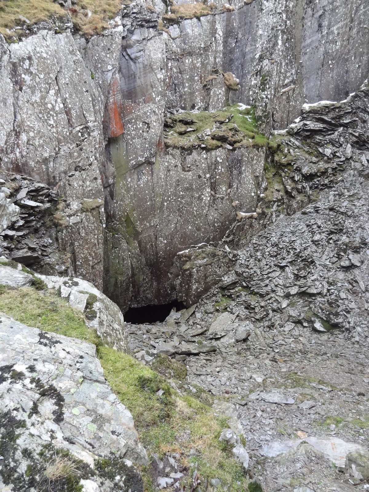
We got to the gate safe and sound and headed for Walna Quarry. The cave in the quarry would make a good place to have our sandwiches i thought. There are actually 2 caves in the quarries, the first one we found to be inaccessible due to a rock fall in the entrance alleyway. This is the biggest cave, so it was a bit disappointing. The 2nd cave is smaller and was accessible but the slate slabs were so slippery we didn't bother trying to get down to it. We were sheltered in the quarry so just decided to find a decent place to sit and have lunch.
Looking round there is still evidence of the quarrymens work. Drill holes ready for sticks of dynamite visible.
Heading down off the tops. Harter Fell now clear.

The 2nd cave which we found too slippery to access.

No sooner had we finished lunch when it went very dark again and the hail started. We set off out through the many quarry buildings, now ruins. There was no shelter.
 Dark clouds approaching fast.

 Sunny one minute.

Dark and hail stoning the next.

The hail was short lived, lasting only 10 minutes. Our route down now joined the Walna Rd again. Coming up to us were two runners and we mentioned to them that it was bitterly cold up on the top. They said they knew already as they had ran over White Pike earlier. We guessed that it must have been their footprints we saw.
Down at the road the temperature was warm and the wind non existent. The layers came off again.
The Woodpecker was still hammering away and the valley had come to life with numerous canoeists.
Greater Spotted Woodpecker, high up in the trees.

Our route today is below. It was 11km. We didn't do this walk in the time showed below on the map. It took us 4 hrs with stops.

Find it Here

About Me

My other blog. beneathwhosefeet.wordpress.com