The Vault Regulars

Saturday, June 22, 2024

West Highland Way, Tyndrum to Bridge of Orchy and return.

 Thursday June 13th. 2024.

It had rained on and off during the night so Sheila informed me. It was still spitting a little when I got up at 7.30am. We decided to do this section of the WHW as we hadn't done it before and we happened to be right on the doorstep. We had done the previous section and also the next sections of the "way", so it made sense to do it. I tried to find a good route back from Bridge of Orchy but there was nothing jumping out at me and at 23km I didn't fancy going much further.

We decided it was easier to return the same way and we shouldn't forget the views would be different going in the opposite direction..

First though, breakfast was needed and we headed for The Green Wellie stop. Wow has this place changed over the years. You can now buy anything and they have been extremely diligent at finding ways to empty your wallet. I have to admit though it isn't TAT and the wifi was fantastically fast. They now do overnight parking at £6 and they have clothes washing and drying facilities for all to use. Currently the prices are, £10 for an 8Kg wash, or £15 for an 18Kg wash and £3 to dry. I thought that was reasonable but I was told that the prices had doubled in the last 18months.

Our usual morning porridge was ordered in the cafe and a black coffee. It was excellent. We set off and it wasn't raining. Bonus. A quick call into the Keystone mini-market for a bar of chocolate and off we went. 

It doesn't take long to get out of the village and into open country where the views are just superb. There are quite a few good places to do a wild camp between the Dam on From Allt and the Auch Estate. 


Beinn Dorain commands your eye more or less throughout the route and what a grand mountain. We had a bit of a laugh about it. It went like this:- There was 2 hikers in front of us and I noticed his tent, so I said to Sheila "that's a Big Agnes". Sheila said "right"! Strange name for a mountain, Big Agnes. I look at her and said "what"?She said "you just said "That's Big Agnes"........ So from then on Beinn Dorain was renamed Big Agnes.

A couple caught us up, said morning and left the track to ascend Meall Buidhe and Beinn Odhar. It was certainly a great day for it. Even though it was a very warm day there was plenty of water around.

Beinn Dorain. (Or Big Agnes depending on who you talk too).

We were quite surprised how quiet the route was, it certainly wasn't busy and I guess we saw about a dozen hikers in total between Tyndrum and Bridge of Orchy. However there was littering all along the route. Mainly tissues, probably a whole box and a few water bottles.

The views opened up and although the A82 is handrailed it wasn't noisy at all and the wide expanse of the glen is wonderful. Passing through the Auch Estate it was a hive of activity. There was tree removal, large drainage pipes being installed, new offices and visitor facilities built. It must be costing a fair bit of money. There was also a herd of highland cattle and calves.


Approaching Bridge of Orchy.

Soon the first sights of Bridge of Orchy came into view, then the platform of the railway station. We had to go under the railway line and follow the approach road down to the main road and into the hotel. A new pub is being built in the old school house which will be called "The 60 Miles Inn". A very clever name. It is going to be a posh place with Pods and hot tubs etc. The West Highland Way has certainly brought a lot of money to Scotland and if any of you can remember when it was first drawn up many people in the Outdoor world said it wasn't needed. How wrong they were.


Yummy.

The hotel was quiet and we were served straight away with Coffee and a large slice of stunning carrot cake. Then it started raining. Just a shower but it was enough to get us back up and moving on our return journey to Tyndrum.

We had numerous showers but nothing heavy. The skies were laden though and we thought it wouldn't be long before we have a downpour. We had time after about 5km to stop for a coffee and a sandwich. then it started to rain heavily and waterproofs were donned. It rained most of the remaining walk so we had to call into the Tyndrum Arms for refreshments. It would have been rude not too.

Yes we put money in the box. Fantastic organisation.

A bit grimm.

We were really pleased we did this route because it is a pleasure to walk it.23km


Wednesday, June 19, 2024

Trail Designs Caldera Kit.

 19th June 2024.

I am reluctantly selling my Stove System.

…………..NOW SOLD …………..

It consists of The Trail Designs Caldera Cone, Aluminium,  which is made the suit the Evernew Eca251 600ml UL pot in Titanium, included.

Also there is a brand new unopened 12-10 methylated spirit stove.

Methylated spirit bottle.

Original screw thread fastening container.

Used, except for new burner.

As shown below. All in good condition.


£50 the lot including post and packing., I think this is a reasonable price considering a new pot alone would be £50. All new would be in the region of £120

Any questions, please leave in the comments below. Thanks.


Sheep Walk, Auchtertyre Farm, Near Tyndrum.

 Wednesday June 12th 2024

I picked this route out from Walk Highlands (WH) library which I use quite a bit. Here

To extend this "short" walk we decided to walk a section of the West Highland Way South from Tyndrum and then a reverse route back. I will ignore this section for now.

The forum walk is graded as a 2 boot walk. Boggy in parts, pathless with some navigation required and overgrown in summer.

We didn't cross the busy A82 road into Auchtertyre farm but used a walkway located underneath the river bridge which gets you to the other side of the road in safety. Follow the farm road where there are a number of places to park a car if needed. 

Walk across the bridge into the Wigwams complex. This is now closed I think, as all the "Cabins" were in poor condition and had numerous pad locks on each of them. From what we saw there is camping for West Highland Way Folk, but don't take my word for it, ring them or email them to be certain.

At the far side of the bridge on the left, a double galvanised gate, which is tied up needs to be entered. Here within a tall bush hides the finger post giving direction. Follow this lane up hill, there is no sign for Disabled Parking as far as we could see but there was a number of half hidden signs saying woodland walks but these are easily missed and are not part of this route. 

As you gain height you walk under a railway bridge which looks like a relic from the past, but it is still a main line track. Once into open country it becomes difficult to find a path on the ground. We set a compass bearing of NE and headed along the bearing up to 290 metres as per the map provided by WH.

Part way up we came across a wooded boardwalk across a dry burn and then a few stumps in the ground. We followed this sheep trail over a couple of other boardwalks and walked more or less parallel with the evergreen old forestry.

When the forestry gave way to newer deciduous woodland we looked for a stile or access through the fence. At a solar powered electric box beside the fence we found a stile. I checked the map and this was the stile shown on the WH map. Having crossed over there was a sort of track heading downwards. We followed this as best we could but it wasn't easy. It was massively overgrown and soaking wet through. Deep tussock grass with slippery descents. 

As we arrived as close as we wanted to get to the stream we headed up stream on a non existing path. We never found the picnic bench or footbridge.

Sheila was not a happy bunny. I was in front bashing my way through the jungle with a piece of old fence post I found. It was horrendous. I went slightly higher and I found a bit more access but it wasn't easy and in parts quite dangerous as the gorge was steep in parts. 

At a point where we were about to give up we came across a boardwalk. Thankfully we now had a clearer route which led to a dam/water turbine and the footbridge leading upwards to a good farm track.

We sat down in the sun to dry off and have a coffee and sandwich. We wasn't sure whether to laugh or cry. That was horrible. We were also shattered.

The farm track is easy to follow and has good views all round. It passes some very old sheilings. When the path runs alongside the woodland and the gorge again we spotted the picnic table across the river. However the footbridge which is mentioned in the WH description is now fenced off and access has been denied. Please take note! 

The track drops down you to the start of the walk.


One sheep didn't make it through the winter.


Map courtesy of Walk Highlands.
The nasty bit is from where it says "Waterfall" to "FB".


Sunday, June 2, 2024

Rab Downpour Eco waterproof jacket review. (First Outing)

 Saturday 1st June.

 Having being totally underwhelmed with my Marmot Pre-Cip I scanned the internet, reading reviews on other jackets and also armed with some knowledgeable info provided by fellow blogger Afoot in the hills, we went to Manchester shopping.

I was disappointed with Cotswold, which is very unusual. I asked the guy, "what is the specification difference between the Eco and the Downpour Light jackets". The answer, "one's heavier than the other".  That was it. I think after 60yrs of hiking I can tell if one jacket is heavier than the other without asking. 

I used my phone and scanned the card attached to the jackets. Easy.

Anyway cutting my buying story short I plucked up the courage, walked through the minefield and bought the Rab Downpour Eco at £125. I could have got it from Go Outdoors for £112.50 or Taunton for £100, but I didn't realise until the deal had been done, or I had been done.


So what is the Downpour Eco.

It is a lightweight, packable, no frills jacket for everyday use and day hiking. Manufactured in good old Bangladesh.

I say day hiking rather than backpacking as the material would not stand the rigours of long days carrying a heavy rucksack. Day sack, ok.

Mine is size large and it weighs in at 362grams.

Size L is a std UK sizing. Fits well.

Material. 100% re-cycled face fabric. Fluorocarbons are only present in the zips. Total recyclable content of the whole jacket 77%.

Material is Pertex revolve fabric. 2.5 layer. 50 denier.

Membrane is polyester.

Waterproof rating----20,000mm/MVTR

Breathability----20,000g/m2/24hr.

The hood is not helmet compatible. Applause all round, we have a hiking jacket with a hood made for walkers. And its a good one, fits well and adjustable front and back. It moves with the head so vision is not obstructed. In the photo below I am wearing a peaked cap under the hood, which I always do as it supports the jacket peak which although it does have a polymer support is not good enough to actually be useful. This point goes for many jackets not just this one.


Length of the jacket is excellent and has a slightly lower tail.

All the zips, 5 in total, made by YKK are water resistant and are all covered with rain guards. The main zip has a press stud top and bottom. I really wished that they had put another press stud just where the colour change happens in the top picture. Simply because I don't always have the zip fully closed and this then allows the guard to blow open. Cost wise --would be negligible. Considering the cost saving made by not having fully waterproof zips.

Pockets. Only 2 zipped waist pockets. No chest pocket, no internal pocket. The actual pocket is not mesh which surprised me but is the same material as the rest of the jacket.  Do I think this is a good idea? I am swaying towards no as there is no means for water both condensation and rain to escape.

I like the fact that an OS map will fit inside the pockets but make sure it is in a waterproof bag just in case.

Pit zips are included as is waist hem tensioner.

Sleeves. I liked the sleeve length as the bottom of the sleeve covers to the end of my fingers. Closure is by hook and loop as std. Sleeve width at the cuff is a little tighter than I would like but it's ok as long as you don't want to get a thick pair of winter insulated gloves under the cuff.

DWR is fluorocarbon free.

The jacket is easily packable into its own pocket.

That's the jacket then, so how do the first testing go:-

I didn't have to wait long for a rainy day and I decided to do the exact same route as I did wearing the Marmot Pre-Cip so that I had a direct comparison.

The ambient temp was 13C today so 5 degrees warmer than previous test. Humidy was high at 88% and barometric pressure was 1007.

It rained most of the walk which was 2.5 hours in time and I purposely kept all the zips closed. 

The problem with waterproof and breathable jackets is that they don't work together very well. If the jacket is dry then breathability will be good but as the jacket wets then breathability reduces. This is science and goes for all jackets whatever the price, name or material.

The inside of the jacket creates its own micro climate, it warms up as body heat increases and the membrane allows moisture vapour (not moisture) to escape. But as said above, this only happens until the jacket face fabric wets out. DWR what ever it is made from will eventually allow wet out to happen.

Also, the warm air between your clothes and the jacket membrane will condensate as soon as you start to vent the jacket. The internal cooling air is no longer water vapour. It is now moisture and cannot evacuate the jacket. This now causes the inside of the jacket to become damp. And where does that damp go? Of course onto your immediate layer of clothing. 

Is there a way around this problem? I don't think so. You have to choose the correct layering system which will allow your first layer to wick sweat away and another layer on top which is not moisture absorbent even when damp.

When I completed the walk I took off the jacket to find my polyester fleece was damp just around the top of the shoulders and a little around my back bones. My capilene base layer was totally dry.

The jacket had wetted out in just a couple of small areas. See attached photo's below. And also there was visible condensation too. However there was no comparison to the Marmot pre-cip which wetted me right though, and considering the Marmot test was 5C lower temperature.

The photos below can be clicked on for a larger view.

The water beading was good but you can see some patches of wetting out.

Patches of condensation on the sleeve top.

Condensation on the area of the shoulder blades. I wasn't sporting a rucksack.

2 photos where there was slight wetting through on the sleeves.

So that is my first outing review of the Downpour Eco. 

I think it went well, I wasn't wet through but just a little damp. I definitely like the design of the jacket itself and the feel of it too. I'm not sure about the pockets and the front zip protector. As I have mentioned earlier, I think a lower press stud would be beneficial.

All in all I'm much happier than I was with the Pre-Cip.

Also, have a look at jackets made with Gore Infinium if you are looking for this type of waterproof.

PS. Waterproof jackets are a minefield. Ignore marketing bumf.

Update:- November 2025. The comments I made about this jacket I stand by. What I have come to the conclusion of is that a 2 layer waterproof is not fit for backpacking purposes. It is ok for day walks when it might be showery. If prolonged rain, then forget it as you will be wet through in no time. The coating inside wears quite quickly in the areas of rucksack rub and when it wets out, which doesn't take too much time, you get wet.

I would recommend sticking to a 3 layer jacket for backpacking and forgetting all the lightweight rubbish that fills the internet.


Saturday, June 1, 2024

Hexamine Fuel Tablets

 Just a short post which I am passing on information that I came upon by chance. 

Since October 2023 it is now illegal to carry, use or even possess in your shed, garage etc Hexamine fuel tablets without a government licence. If found then you could get a 2 year jail sentence. ( not that there is any room in our jails and I don’t expect that there will be a purge by our stretched Police forces to do shed searches. 

However this is now law and as we know, laws have to be obeyed no matter how stupid. 

Licences are £39.95 if you are from the U.K. and last 3 yrs. If you are a foreigner then you also need to apply for another piece of red tape making sure that you are a fit person to apply for the licence. The mind boggles. 

Anyway all you folk who use solid fuel tablets take note. 


Friday, May 17, 2024

Marmot Pre-Cip 2024 waterproof jacket review.

16th May 2024

For years and years I've wanted a Marmot Pre-Cip but could never justify getting one as I have a wardrobe full of jackets. But, in time jackets wear out and so when three of mine went to the re-cycle bin I bought a Marmot Pre-Cip with my own money after good recommendations from my wife. 

She has had an original Pre-Cip for some years and raves about it. I have read many reviews about it as over the years it became a bit of an iconic jacket. I recall Chris Townsend giving it a good review in TGO Magazine many years ago.

It isn't used for backpacking because it simply isn't strong enough around the shoulders to take all the abrasion a backpack creates, no matter what the ultra lightweights say. But for day walks and as a general waterproof then it's been perfect for her and I wanted a lightweight waterproof so it was a no brainer really, considering the price of £60.


It's a simple waterproof, no frills and very lightweight. Packable into it's own pocket. The hood can be rolled away into the collar. Sleeves have the usual velcro adjusters at the cuff, the hem has draw cord tighteners, a zip rain shield, 2 mesh hip pockets, pit zips and not much else. It does feel very nice, tactile I suppose.

Size wise it is slightly larger than "normal" sizing due to being designed for layering with an insulated jacket. There is plenty of room for layering and also the sleeves are a little longer than std which I don't mind at all and your arms stay protected when reaching high. I find the sleeves a little too narrow if I want to pull the sleeves over a thicker pair of gloves. I hate narrow sleeves.

The weight of my Large is 322gr. The jacket is made in Myanmar, the original Pre-Cip was made in China.

With 2.5 layer 100% nylon material and NanoPro Eco coating, whatever that is, it is said to be very breathable and absolutely wind and waterproof. That's the marketing bumf anyway. 

All excited and ready to try the jacket out I waited for a rainy day and then went for a short walk, about 2 1/2 hrs. It wasn't lashing down or fine horizontal stuff and not torrential, just typical Manchester summer weather.

I walked about 12km with only a few up's and downs. Temperature was 8 degrees C, I din't take a daypack and I was in no rush. I wore a capilene base layer and a polyester fleece and then the jacket.

First time I cinched the hood the tensioning cord pulled out from its secure seam completely. Not a good start, now I will have to find a way to fix it back in.

I din't stop during my walk and never checked the inside of the jacket. When I got home and unzipped the jacket the inside was wet through and my fleece was wet as well. So it doesn't breath very well if at all and I can only suggest that it isn't waterproof to any degree enough for a days hiking.

The next time I went out in the rain Sheila came with me with her Pre-Cip and guess what! My jacket and top were wet through and Sheilas was dry as a bone. 

So what is the difference. The country of manufacture has changed from China to Myanmar. I guess the spec. hasn't changed but where abouts in the spec. does the new jacket lie? Is it at the top end or the lower end? I can only guess it has been a cost cutting exercise and now we have a lower spec jacket. I am not privy to this sort of information but its obviously not as good as the original Pre-Cip. Or the DWR isn't up to the job.

I'm a bit disappointed to say the least as I will now have to find another "Waterproof Breathable" lightweight jacket that will keep me dry for longer.

Can I recommend it? Absolutely not. 

Any suggestions at all for an alternative jacket? as marketing bumf is no indication of how good a jacket is in reality. Thanks. 


Wednesday, May 15, 2024

Whita Hill Circular, Langholm,

 Thursday 9th May 2024.

Whita hill is another prominent height surrounding the village of Langholm. On it's top is a white sandstone monumental needle built to commemorate Major General Sir John Malcolm. There is also a communication mast. Both these objects can be seen for miles around.

Our walk is also number 8 on the Langholm walks list and is classified as MODERATE.

The weather forecast said it would be a cloudy day but it was clear blue sky, no breeze and warming up. A perfect walking day.

Walking past Kilngreen Carpark a fair was being set up for a long weekend. There was the usual caravans and facetiously I said to Sheila "I wonder if they will be allowed to sleep over on the carpark"?

Anyway, across Saw Mill Bridge we went, aptly named from the old (yes you have guessed it) saw mill which used to be on the West Bank of the Ewes river. It used to be water driven as a leat was taken from the river further up stream. The mill or where the mill was is now part of the Baccleuch Estate. The leat long gone.

Before reaching a nice lodge house, turn right and follow a good track rising gradually. When a bungalow is reached take a look right for good views of the days target top. Take a right and follow the path which again has great views and is a pleasure to follow. 

Whita Hill

Soon a gate is reached across the track, go through it and continue on the track to the end of the wall, turn right and look for a galvanised modern kissing gate, don't be tempted to take the steep grassy route straight down to the road.

Go through the gate and follow the left hand fence line all the way round until a LRT (Land Rover track) is reached. Follow this down to a gate and join the main A7 road. 


Go right over the road bridge, known as High Mill Bridge, taking care as this is a main highway. As the road bends right, cross over the road and pick up the good path on the other side which heads in a northerly direction.

Follow this track on level ground all the way until you cross a small burn by a culverted bridge. Follow the path round to the right and a little higher up the path opens out and a path drops off to the left where a ford is crossed. Take the ford and take the onward rising path. On the left the area is known as Target Burn.

Target Burn.

Target burn was a rifle range which was used during both world wars. The OS names it Far Whitshiels Cleuch. At the top of the rise, the path bears right and follows the line of a stone dyke on the left, it was a bit indistinct, overgrown and boggy when we passed here but a stile is soon reached on the left and crossed over into open countryside. 

The views now are stunning.

The route upwards basically follows the fence line. The ground is wet in places, not much of a path but the views get better.


Many ewes with new born lambs kept us company. One lamb in particular was incredibly friendly and came right up to us for a few minutes. Luckily when we got on our way it didn't follow us but bleated for mum.

A sandy track was followed to a galvanised gate. The route doesn't go through the gate but turns left, follows the fence line until gaining the moorland road between Langholm and Newcastleton. 

Across the road we took advantage of a bench for lunch. We started to loose the blue sky and the temperature was taking a dip so onwards and upwards.

Comb Hill (with the mast), and Wisp Hill

Moorland road with Tarrona Hill in the background.

A little further up the road we came to a fine memorial.

The memorial is to Hugh Macdiarmid who was born Christopher Murray Grieve on 11th August 1892. He was a co-founder of the SNP. The poet was educated in Langholm and is buried there.


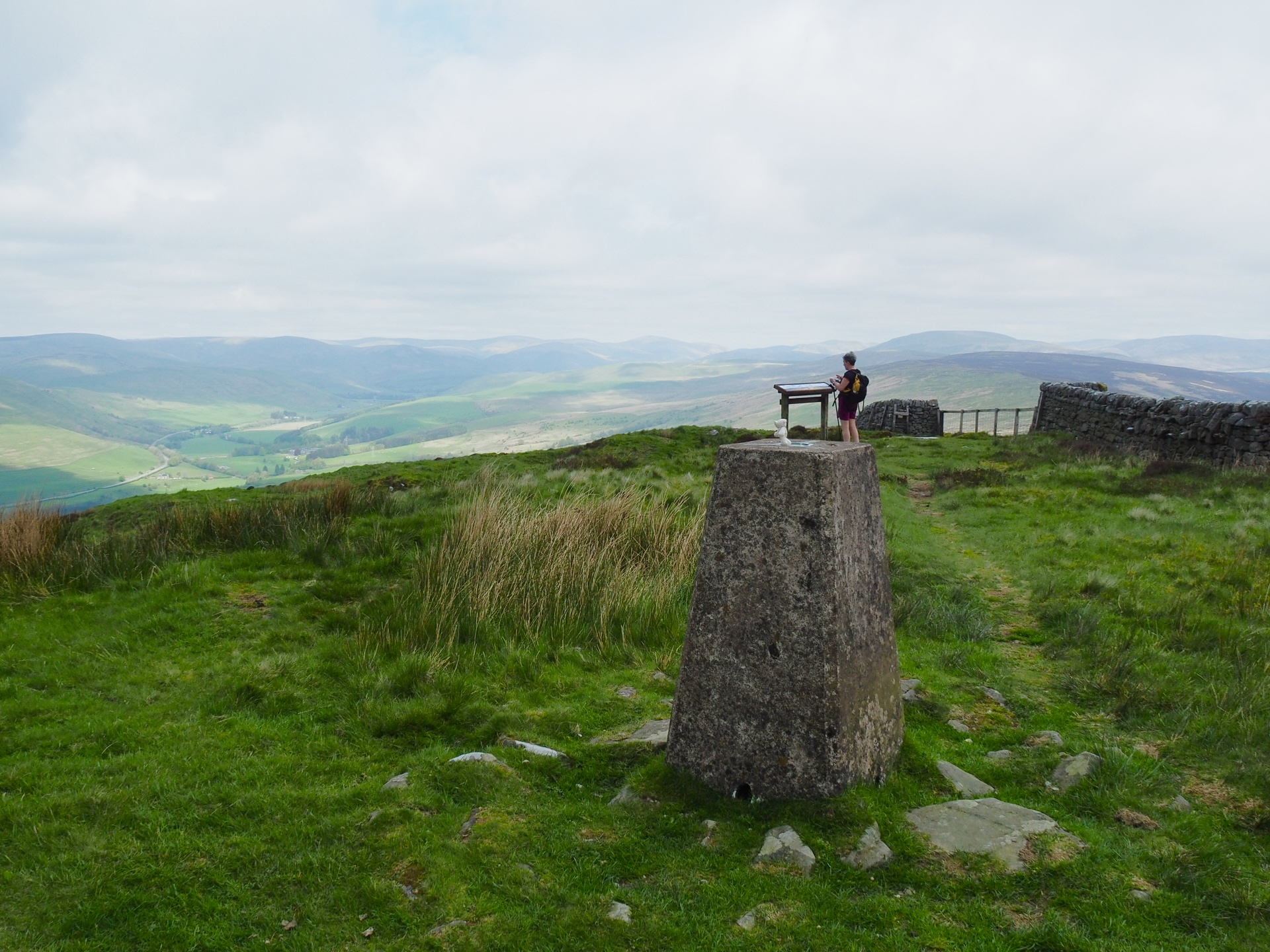
A good track leaves the moorland road all the way to the top of Whita Hill where there is a trig point at 280 metres and a obelisk monument to commemorate the life of Sir John Malcolm of Burnfoot, Langholm.

John Malcolm joined the East India Company at 13 yrs old. Becoming a cadet in Madras he saw active duty against Tipu Sahib, the Sultan of Mysore.

Apart from this monument on Whita Hill there are also monuments in Bombay and Westminster Abbey.

Track up to the monument of Whita Hill.

Trig point with a view.

The John Malcolm Obelisk

If anyone reading this has any idea what this represents, please let me know.

What happened to the blue sky?

Tinnis Hill in the gloom

We were losing the light and the far distant views. After taking a few photos we headed off down hill to find the Whita Well. 

It's quite a steep drop off the top and care is needed in wet weather. Today we were fine and soon came to the cairn and well of the Common Riding.

The wells water is pure and can be tried with the chained up metal cup attached which we did.

Whita well.
A hundred yards further on through a host of gorse bushes is a stile on a green lane leading straight down to Langholm High Street.


Almost back into the village

Our route, clockwise from the boot. 8KM 3hrs including stops.


Find it Here

About Me

My other blog. beneathwhosefeet.wordpress.com