The Vault Regulars

Tuesday, February 12, 2019

A wet Catbells.

After yesterday’s lovely day we were full of enthusiasm to get up and out. I opened the curtains to see, well, nothing. The hill fog was right down and visibility was I guess about 100 metres.
Sheila made a brew and we stayed in bed.
We decided that the best option would be to go for a mooch around Keswick, we needed some supplies etc etc. Keswick was pretty quiet and we had a good chat with the staff in Alpkit about Iceland and dehydrated food. Lunchtime crept up on us, it’s always doing that, and always about the same time, strange that.
Then God forbid, the sun came out. It was very pleasant. Sheila said “why don’t we do Catbells seeing that we are here, it’s sunny and I haven’t done it”. “Do we have to” I said. So we drove to the foot of the hill where you can usually park up mid week, whereas you’ve no chance at weekend. How those folk who live there put up with some of the stupid drivers is beyond me. Why don’t the CCC make a bloody car park instead of making it so damned hard for folk. It’s a busy hill, it always has been. Today was no exception.
Then it rained, and it rained again harder. We set off, and got to the top of the first rise, we met half a dozen folk coming down, looking a bit bedraggled. Sheila then said, “do we have to go up that.” I must admit that in this light with the rain and the mist swirling round it did look daunting but I’d been up many times so I knew it as an easy ascent. I told Sheila that I call this Granny Hill because it’s so easy.
The wind was quite strong and gusting, making the rain lash too. At the base of the main summit rise people were being very careful descending as the rock was very smooth, slimy and slippery. There is an easier ascent on the left of the main rocky route. We took this as it put us in the lea of the wind. Some care was still needed in parts.
At the summit cairn it was dreich and the higher summits up to Dale Head and beyond were in the fog. It wasn’t a place to hang around enjoying the scenery, we took the usual summit photos and set off back down.
We only passed four other people on their way up which is incredible for this hill.
So Sheila has another hill to add to the list. Not that we are counting anymore.
Please click on the images to enlarge them.


Monday, February 11, 2019

Low Fell 412m, Fellbarrow 416m

We woke up this morning to sun bathing the ridge on the west side of Lorton Vale. We had originally planned to do this walk yesterday but the weather forecast was predicted to be better today. They were right.
Parking at a small lay-bye in Thackthwaite, we were the first. I got my rucksack out of the boot and put it against the fence while I sorted my camera out and secured the car.
Donning my sack and fastening the hip belt I found out I had inadvertently placed it in a pile of sheep poop which I now had all over my fleece and my hands as well as the sack. Luckily a beck was on hand so I was able to wash it off. I believe some people say this is good luck.
The path leaves the road in front of Thackthwaite Farm and joins a good green Lane onto the Fell side. This path has all the hallmarks of being an old quarry track but I can only see the one small quarry on the map. At the wall of the last intake field you go through a gate and can walk left or right, we went right. This is the most popular and I dare say the easiest way.

A steadily rising path with stunning views opening up behind you. Directly in front is Fellbarrow and we kept in mind the obvious tracks coming off the top, down to a wall and then crossing Meregill beck. This path is not on the OS map but I expect that it is used often by locals to make a good circular trip.
We had a bit of faffing around, de-layering, and we’re overtaken by three folk. The path zigzags it’s way upwards, going through two gates before reaching the watershed where the views south start to open up. All the tops of Buttermere and the Grasmoor group with some light dusting of snow are spectacular.
We stopped on a high point just beyond Watching Gill and enjoyed the view.
Up one more rise, over a stile and we were on the ridge to the top. This has to be one of the best views in the Lake District. The scene down Crummock Water is fantastic. Unfortunately the sun was in our face so not ideal to capture such a wonderful view at its best.
 After being blown away by the beauty we headed back to the top of the watershed where we handrailed the fence line to the top of Sourfoot Fell, Smithy Fell and then the steep pull up to the summit of Fellbarrow with its OS trig point.
From the summit there is a grand view of the west Cumbrian coast, the Solway estuary, the Isle of Man, Dumphries and Galloway and the tops of Skiddaw and Blencathra. Luckily for us there was little wind and although it was chilly we still lingered a while before descending by the track we had spotted on the way up.
A real fine day out. Please click on images to enlarge them. All taken on iPhone 6.


Sunday, February 10, 2019

Warnell Fell summit trig point.

Not much to write home about, but a short walk from Caldbeck to Warnell Fell trig point. Freezing cold wind but great views across to Carlisle and the Dumphries hills.


Saturday, February 9, 2019

A circular route round Loweswater.

There are lots of parking places at either end of the lake, we parked at Waterend, next to the public phone box. We set off in a clockwise direction picking up the lakeside path as soon as possible to get off the tarmac. The road is not particularly busy but it’s nicer to walk on a path than a road.
Weather wise, it was a good start, chilly but high cloud and those strong winds of late had died down.
The fells surrounding Loweswater are steep and inviting. The light changing the colours on the fells as clouds move over them. At times you think it’s summer and 5 minutes later the same view links winters. I cannot remember a valley which is so influenced by changing light.
As we made our way towards Loweswater village we passed properties that scream out history. Crabtreebeck, High Thrushbank with a mill stone positioned in the garden and the imposing frontage of Highcross.
There’s an information board at an old sheepfold which we read was a “Pinfold”, not a word I have come across before. It’s where stray sheep were put so that they could be collected later by their owner after they had paid a fine to the “Pinder”. It dates from 1655. Not so good old days were they.

We turned off the road and crossed Maggie’s bridge where there is another car park. There are numerous paths leading off from here but to follow the lake path we took the one past Watergate Farm, a National Trust property with some self catering accommodation. There’s a bothy in Holme Wood which is in a terrific position with great views. It’s basic just like any owned by the MBA but this one differs in the respect that the MBA bothy’s are open and free to the public, this one owned by the National Trust is locked and charges £60-£70 per night for the privilege of staying in a stone tent.
There are signs everywhere saying that Red Squirrels are about but search as we did we found none. Sheila was a bit disappointed.
The woodland is mixed and looks well managed, the paths are good, so it made us feel even more stupid that I fell once and Sheila twice. I’ve a great lump on my shin and Sheila has a cut knee and a sore hand. Oh well.
Once out of the woods the path passes Hudson Place, an old farm with a plaque which said 1641 I think it was. Five minutes later we were back at the car. A nice couple of hours walk.


Friday, February 8, 2019

Inov 8 All terrain pro mitt.

The choice of gloves and mitts on the market is seriously mind blowing. From Aldi to Arcteryx, the costs vary so widely too.
Like most serious walkers, my glove drawer is packed with so many different brands and materials that have failed in one way or another or are so dedicated to certain conditions or terrain that they don’t get used often enough.

 I’ve tried for years and years to find a pair that will suit my walking conditions month in month out. I would just like to emphasise that I mean “my walking conditions” which doesn’t include climbing, a bit of scrambling maybe, but not running, biking or rafting.

 I have been involved in the Duddon Valley Fell Race for 25 years or so and I always make a point of checking out the gear which is for sale on the Pete Bland sales van. It’s also interesting to see what gear the fell runners themselves have chosen because they run in some dreadful conditions.
 I noticed that the Inov 8 All Terrain Pro mitt was one that stood out from the crowd. So when the opportunity presented itself I bought a pair for myself.
I’ve tried them out now in all conditions including snow.


The mitts, which I have, as opposed to the glove are extremely light weight at 47 grams per pair in size Large. They have a close fitting stretch cuff and a warm lining.
The important parts ie the outer material and the seams are made from 90% nylon, 5% Polyester and 5% TPU. The seams i am guessing are heat sealed rather than taped. There are no tell tale signs of taping but are incredibly watertight. I am guessing heat sealed because TPU lends itself to that method of sealing and is used extensively in water sports etc. but I am not going to damage the glove to make sure.
I emailed Inov-8 with a question about the seams but although i received a response from them i didn't find out either way.
They are designed to wear over the top of a liner glove if required and I agree that this combination works well, giving the variability to modify what you wear depending on the conditions encountered and therefore prevent overheating or visa versa.
They come with elasticated wrist straps so that you can take them off and they won’t blow away and I found this very useful.
I have used them them on there own and they are warm. I have used them with a pair of Rab merino liner gloves and also a thin pair of possum wool liners and I have doubled up the liners just for the review but they were too warm.
Having a combination glove set that weighs 100 grams in total (3 pairs)and takes up hardly any pack space is  a winner for me and I would recommend TGO challengers to seriously consider these.
If I had to find a fault I would say that the elasticated cuff would have been better adjustable. It’s quite a tight fit and if you are a person with stout wrists then they may not suit.


Wednesday, February 6, 2019

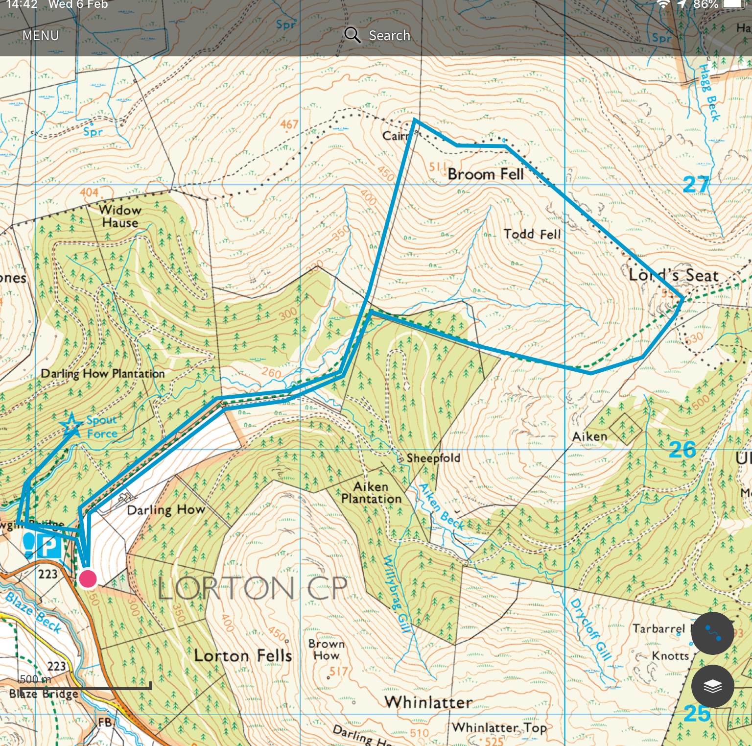
Spout Force, Broom Fell 511m and Lord’s Seat 552m

The car park at the bottom of the road which leads to Darling How farm has plenty of space for a dozen or more cars. This is where we parked for a quick visit to Spout Force waterfall. It’s quite a steep drop down to the river so an alternative route starts from Scawgill Bridge where the path is gentle.
The falls are not huge and not particularly spectacular but worth a visit due to its close proximity to the car park.


From the falls we headed back to the car and picked up our walking poles and headed along the track past Darling How. It’s a good forestry track until you leave the road where it becomes a soggy slippery path. There’s a beck to cross and today it was flowing fast but still easy to cross. The path meanders until exiting the forestry where you’re then faced with contours, lots of them and they are all very close together and in parallel. Over a stile you then handrail a fence all the way to the gut busting summit of Broom Fell, (Birkett, Synge. 511 metres.) where there is a 2 metre cairn and a much needed wind break. It was fierce up there, some people say fresh but when the wind pushes you over its fierce in my book. The act of placing one walking pole in front of the other was difficult.
Sitting in the windbreak and allowing the wind to make funny faces a lone Fell runner crossed the stile, said hi and slowly moved off at a few yards per hour. Madness.
I was a little hesitant whether we should go across to Lords Seat or if we should head down to more sheltered territory. The wind was blowing in the direction of Lords Seat so we carried on. It was hard but not as hard as going in the opposite direction. Sheila’s Fitbit heart rate went spiking up into the red and she said as much too. We were pleased to see the top. 552m (Marilyn).
We didn’t stay long on the top, just long enough to take photos from a lying down position. The path down followed the fence SW towards Aiken wood for a few hundred metres and then turns away West and heads down to a walled gap in the forestry.
Finding some respite from the wind in the forest we had our first and only break, a much needed coffee and sandwich. We hadn’t been stopped 10 minutes when we felt the first signs that rain was on its way.
The walled gap provided a couple of photos of some beautiful fungi. ID not known to us right now but we will check up later.
Once across the beck again we were soon back on the forestry road and heading to the car. The rain became heavier and waterproofs were needed. Yes, I had packed them today.
8.5km and I felt every metre.


Tuesday, February 5, 2019

A short walk in the Vale of Lorton

Not much walking of any interest has been done by us of late, again due to the poor health of Sheila’s mum who is once again in hospital. At the moment we are sharing responsibility with family. This has given us a chance to get away and we landed up in the Vale of Lorton.
The morning started off with calm weather, some cloud and occasional blue sky. It was quiet, very quiet.
Heading out and picking up the fell road and then hill track past High Swinside we came across our first obstacle Hope Beck. Due to the recent snow melt the beck was running fast and high. We went up and down until we found a place that looked ok to cross.
The scenery on our left is steep territory Dodd, Penn, Whiteside End filling the view. In the distance Mellbreak and the Buttermere ridge with remnants of recent snow.
I stopped to take a photo only to realise that I had dropped my glasses. We retraced about 500metres and found them.
At Gasgale Gill we crossed the footbridge and the valley road and headed up to Scales Hill which we were told had great views. We wasn’t disappointed. Fantastic views down Crummock Water.

Having lunch I found that I had no waterproofs. I had stupidly left them in the car. The forecast was for rain at 2.00pm. We were enjoying watching a Barn Owl hunting but we had to get a move on and at 1.00pm the first drops started. With only about 10 minutes to the car the rain started quite heavily and the scene changed to one of murky ghostly hill shapes as the rain swept in. It was only 15 minutes after we got back that the weather changed dramatically with heavy rain, strong gusts of wind and no visibility.
What a difference 4 hours makes in the Lake District.
        11.85km

Friday, November 9, 2018

Baselayer by Craft.

It’s that time of year again when we start to feel the chill as we tread those hills. It’s been good for Sheila and I to get out recently and it’s also given me the chance to test some gear too. It’s been typical UK weather in the Lake District and South Wales, we have had torrential rain, hail, high winds, freezing winds, cold frosty nights, sunny hot days, we have had everything but snow.

If your backpacking or daypacking it doesn’t matter,  if you are carrying a pack in the outdoors then your going to sweat, especially where your pack touches you. So it’s important that your baselayers wick sweat away and most importantly have the ability to dry quickly. You definitely don’t want sweat freezing your body when you stop.

There are lots of makes and materials out there, it’s not easy to find one that works and you can pay fortunes only to find out that it’s not as perfect as the blurb first gave you the impression that it would be.
For example Merino wool. Expensive unless you buy one off Aldi, which to be honest I have found to be good value for money. I even bought the “new”  Ultra Merino a while ago when it first came onto the market in New Zealand. I don’t think it’s available in the UK yet but I could be wrong. It proved to be pretty useless as far as backpacking was concerened.
It was warm, it was comfy but it doesn’t wick the sweat as it was supposed to do, and when wet it feels awful, like soggy cardboard, and just like soggy cardboard it takes an age to dry. I found that even hanging up in reasonable conditions that it wouldn’t dry overnight meaning you were putting damp wool back on. Not an unusual scenario when backpacking but if you don’t need to do that then why do it.

For me, the best next to skin baselayer I have used is the Rohan Ultra Silver Tee, I have both long and short sleeved versions. They work fantastically well and don’t hold sweat. They don’t smell bad either after days of wearing. They look and feel like silk and they weigh less than 100 grams. They dry amazingly fast and if you have never tried one then I recommend you do before Rohan decide to improve them or worse still discontinue them. On occasions I wear the short sleeve one under the long sleeve one because layering is the best way of keeping warm.

As examples go I have highlighted 2 here, one that works and one that doesn’t. I’ve tried many.

Now bring on the Craft baselayer. I had never heard of these, neither from advertising or gear reviews or even from the outdoor community I regularly talk too. I came upon this brand by fluke.
I was looking at lightweight shell jackets in Evans cycling shop but I didn’t want one with a pocket on the back for obvious reasons. Chatting with the staff I was out of luck, but we chatted about hiking rather that biking and the subject of baselayers came up. I was introduced to Craft who make cycling and running apparel.
I was impressed with the material, the design, the ventilation and the weight. I bought one (they actually only had one left in Large size).  I wore it a few days and liked it so I searched the web and bought a second one.

Craft base layer. Extreme Active 2.0 SS.

On first wearing, i was not sure if i liked the high collar, it felt a little claustrophobic. But after  few hours i got used to it and now i don't notice it. I wear it regularly, not just for hiking.
The underarm venting is welcome and also the tops are very long in body length, much longer than what you would normally receive from a hiking top. I am very pleased with this feature because it doesn't ride up your back 
Material wise i would say it reminds me a little of Patagonia Capilene, not the same but similar. 
It works very well at wicking sweat away and dries very fast. It feels good next to the skin.

Weight, very light, the large size short sleeve top is only 99 grams.
The fit is athletic and although the material has elastine which allows some stretch i would say for hiking pick a size up from normal tee shirt size if your interested in buying one. Prices are mid range. 

The company have a large product offering and good designs, definitely worth a look, click here to check it out.

Thursday, November 1, 2018

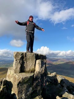
Sugar loaf mountain 596m


A fantastic hill for day walks. Lots of routes you can make it a long or short day. 

Tuesday, October 30, 2018

Blorenge, a fine hill walk.


I’m keeping this short and sweet so hopefully blogger will accept it.
A lovely day hike with lots of industrial archeology from the mining industry.Tramroads, railways, quarries, ponds and much more. Millions of years ago the area was under water and there’s still evidence of sea bed in the stones strewn everywhere. The paths are good and scenery stunning. But boys was it flipping cold. 5 layers on today.

Monday, October 29, 2018

Monmouthshire canal and disused railway line.

Monday 29th October 2018

Sorry that the images are not in sequence, blogger is not playing ball.


We needed some supplies and also to recee where the Bear Hotel was in Crickhowell. We are due to meet friends here tomorrow night.
Crickhowell is a lovely village with cobbled streets and tiny alleyways. There are plenty of shops and also a castle to have a look at. There’s not much left of it but it’s srill interesting.
The town suffered very badly during storm Callum this year and they are still recovering and repairing the damage.

Walk wise, we drove and parked up in Govilon next to the disused railway line. This used to be the Abergavenny to Merthyr line until it became part of the larger London, North Western Railway. The line was closed like many were in 1958.

We only stayed on the line past Govilon station where we diverted onto the Monmouthshire and Brecon canal, which is still in use leisurely today. It’s a fine canal walk with stunning views.
Just past Gilwern we had to ask if we could get back onto the old railway line. This was because there is a massive new road structure cutting through the valleys and all the os maps are out of date. As it happens a new footbridge has been built across the highway and it gave us access to the minor roads that lead to Gilwern halt. Phew, it was a steep climb.

Many original buildings have been privatised and the old station is still there. Even though it was closed so long ago it is easy to imagine how it all looked.

A Buzzard kept us entertained on our walk back to the car, flying low over our heads and using the trackway like a runway. It was great to watch such a big bird close up.

Find it Here

About Me

My other blog. beneathwhosefeet.wordpress.com